You are here: Home > Network List > TA - USArray Transportable Network (new EarthScope stations) Stations List
> Station T06C Millerton Lake Dam, Friant, CA, USA > Earthquake Result Viewer
T06C Millerton Lake Dam, Friant, CA, USA - Earthquake Result Viewer

| Earthquake location: |
Off Coast Of Chiapas, Mexico |
| Earthquake latitude/longitude: |
15.0/-94.2 |
| Earthquake time(UTC): |
2006/06/27 (178) 13:03:12 GMT |
| Earthquake Depth: |
29 km |
| Earthquake Magnitude: |
5.4 MB, 5.5 MS, 5.8 MW, 5.8 MW |
| Earthquake Catalog/Contributor: |
WHDF/NEIC |
|
| Network: |
TA USArray Transportable Network (new EarthScope stations) |
| Station: |
T06C Millerton Lake Dam, Friant, CA, USA |
| Lat/Lon: |
37.01 N/119.71 W |
| Elevation: |
216 m |
|
| Distance: |
31.6 deg |
| Az: |
318.792 deg |
| Baz: |
127.304 deg |
| Ray Param: |
0.07897669 |
| Estimated Moho Depth: |
54.25 km |
| Estimated Crust Vp/Vs: |
1.60 |
| Assumed Crust Vp: |
6.291 km/s |
| Estimated Crust Vs: |
3.932 km/s |
| Estimated Crust Poisson's Ratio: |
0.18 |
|
| Radial Match: |
80.74249 % |
| Radial Bump: |
400 |
| Transverse Match: |
62.06105 % |
| Transverse Bump: |
400 |
| SOD ConfigId: |
2665 |
| Insert Time: |
2010-03-07 02:13:30.817 +0000 |
| GWidth: |
2.5 |
| Max Bumps: |
400 |
| Tol: |
0.001 |
|
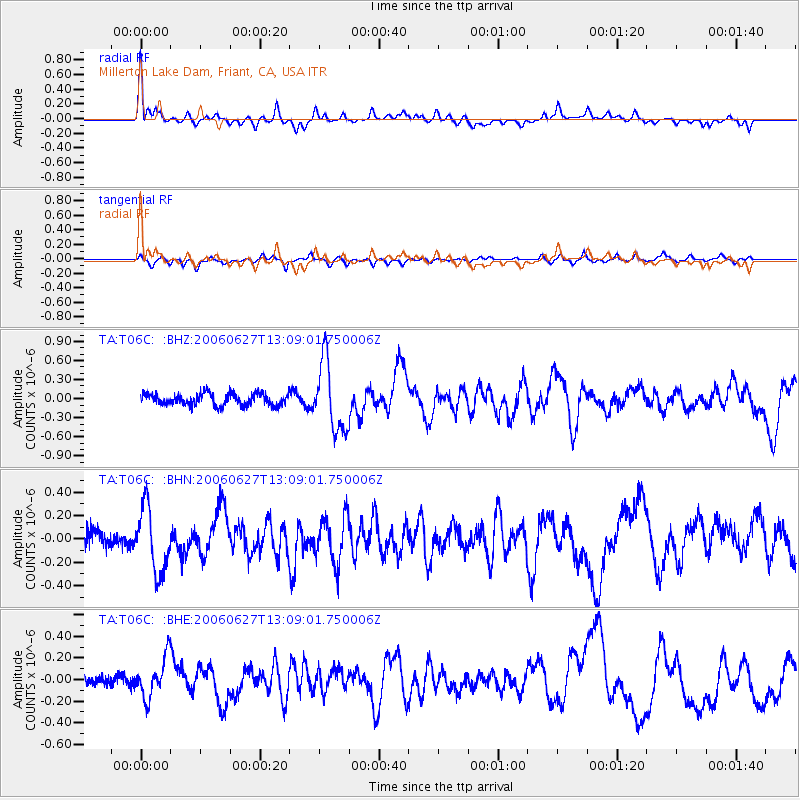
Signal To Noise
| Channel | StoN | STA | LTA |
| TA:T06C: :BHN:20060627T13:09:01.750006Z | 4.184767 | 2.7859056E-7 | 6.657254E-8 |
| TA:T06C: :BHE:20060627T13:09:01.750006Z | 3.443782 | 1.8202803E-7 | 5.285701E-8 |
| TA:T06C: :BHZ:20060627T13:09:01.750006Z | 5.986568 | 5.454577E-7 | 9.1113584E-8 |
| Arrivals |
| Ps | 5.6 SECOND |
| PpPs | 21 SECOND |
| PsPs/PpSs | 26 SECOND |


