You are here: Home > Network List > TJ - Tajikistan National Seismic Network Stations List
> Station GARM Garm, Tajikistan > Earthquake Result Viewer
GARM Garm, Tajikistan - Earthquake Result Viewer
| Earthquake location: |
Philippine Islands Region |
| Earthquake latitude/longitude: |
20.8/122.0 |
| Earthquake time(UTC): |
2019/07/27 (208) 01:24:44 GMT |
| Earthquake Depth: |
10 km |
| Earthquake Magnitude: |
5.7 Mww |
| Earthquake Catalog/Contributor: |
NEIC PDE/us |
|
| Network: |
TJ Tajikistan National Seismic Network |
| Station: |
GARM Garm, Tajikistan |
| Lat/Lon: |
39.00 N/70.32 E |
| Elevation: |
1305 m |
|
| Distance: |
47.7 deg |
| Az: |
304.227 deg |
| Baz: |
96.853 deg |
| Ray Param: |
0.06980896 |
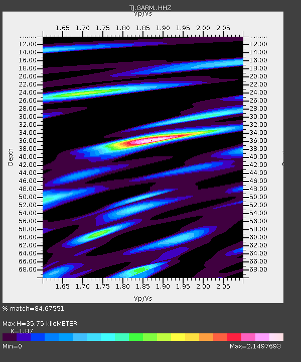
| Estimated Moho Depth: |
35.75 km |
| Estimated Crust Vp/Vs: |
1.87 |
| Assumed Crust Vp: |
6.306 km/s |
| Estimated Crust Vs: |
3.372 km/s |
| Estimated Crust Poisson's Ratio: |
0.30 |
|
| Radial Match: |
84.67551 % |
| Radial Bump: |
311 |
| Transverse Match: |
61.646076 % |
| Transverse Bump: |
395 |
| SOD ConfigId: |
19053131 |
| Insert Time: |
2019-08-10 01:30:30.727 +0000 |
| GWidth: |
2.5 |
| Max Bumps: |
400 |
| Tol: |
0.001 |
|
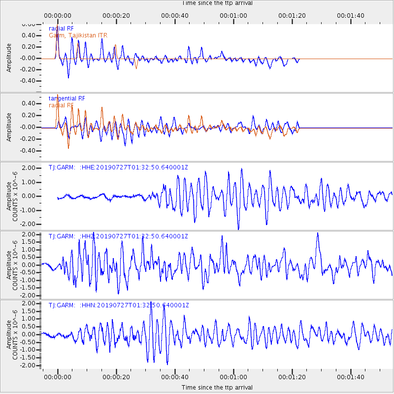
Signal To Noise
| Channel | StoN | STA | LTA |
| TJ:GARM: :HHZ:20190727T01:32:50.640001Z | 3.2128718 | 4.1027016E-7 | 1.2769578E-7 |
| TJ:GARM: :HHN:20190727T01:32:50.640001Z | 0.7719128 | 8.992972E-8 | 1.16502434E-7 |
| TJ:GARM: :HHE:20190727T01:32:50.640001Z | 2.2699091 | 2.2353565E-7 | 9.84778E-8 |
| Arrivals |
| Ps | 5.2 SECOND |
| PpPs | 15 SECOND |
| PsPs/PpSs | 21 SECOND |


