You are here: Home > Network List > TA - USArray Transportable Network (new EarthScope stations) Stations List
> Station T06C Millerton Lake Dam, Friant, CA, USA > Earthquake Result Viewer
T06C Millerton Lake Dam, Friant, CA, USA - Earthquake Result Viewer
| Earthquake location: |
Tonga Islands |
| Earthquake latitude/longitude: |
-20.6/-173.9 |
| Earthquake time(UTC): |
2006/05/17 (137) 03:06:16 GMT |
| Earthquake Depth: |
10 km |
| Earthquake Magnitude: |
5.8 MB, 5.8 MS, 6.0 MW, 5.8 MW |
| Earthquake Catalog/Contributor: |
WHDF/NEIC |
|
| Network: |
TA USArray Transportable Network (new EarthScope stations) |
| Station: |
T06C Millerton Lake Dam, Friant, CA, USA |
| Lat/Lon: |
37.01 N/119.71 W |
| Elevation: |
216 m |
|
| Distance: |
76.8 deg |
| Az: |
41.85 deg |
| Baz: |
231.319 deg |
| Ray Param: |
0.0507435 |
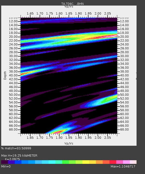
| Estimated Moho Depth: |
19.25 km |
| Estimated Crust Vp/Vs: |
2.10 |
| Assumed Crust Vp: |
6.291 km/s |
| Estimated Crust Vs: |
2.999 km/s |
| Estimated Crust Poisson's Ratio: |
0.35 |
|
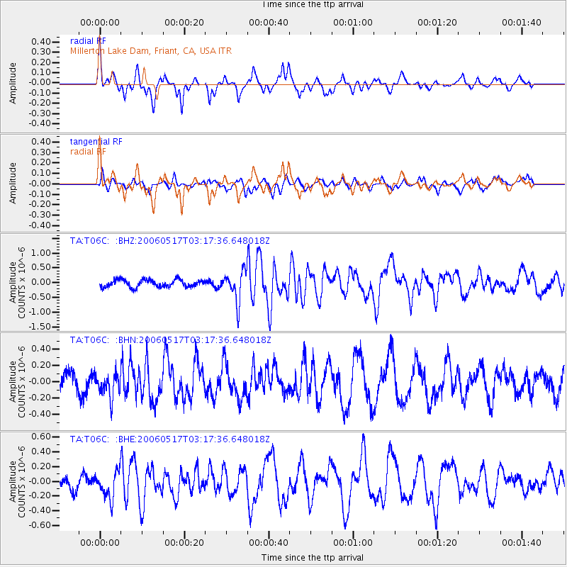
| Radial Match: |
83.58999 % |
| Radial Bump: |
326 |
| Transverse Match: |
55.67837 % |
| Transverse Bump: |
400 |
| SOD ConfigId: |
2669 |
| Insert Time: |
2010-03-07 02:13:38.743 +0000 |
| GWidth: |
2.5 |
| Max Bumps: |
400 |
| Tol: |
0.001 |
|
Signal To Noise
| Channel | StoN | STA | LTA |
| TA:T06C: :BHN:20060517T03:17:36.648018Z | 1.099353 | 1.5647869E-7 | 1.4233709E-7 |
| TA:T06C: :BHE:20060517T03:17:36.648018Z | 1.3337355 | 1.861822E-7 | 1.3959456E-7 |
| TA:T06C: :BHZ:20060517T03:17:36.648018Z | 4.155439 | 5.206493E-7 | 1.2529344E-7 |
| Arrivals |
| Ps | 3.4 SECOND |
| PpPs | 9.2 SECOND |
| PsPs/PpSs | 13 SECOND |


