You are here: Home > Network List > TA - USArray Transportable Network (new EarthScope stations) Stations List
> Station I20K Naaghedeneel ne tl'uh kk'aat, AK, USA > Earthquake Result Viewer
I20K Naaghedeneel ne tl'uh kk'aat, AK, USA - Earthquake Result Viewer
| Earthquake location: |
Philippine Islands Region |
| Earthquake latitude/longitude: |
20.8/122.0 |
| Earthquake time(UTC): |
2019/07/27 (208) 01:24:44 GMT |
| Earthquake Depth: |
10 km |
| Earthquake Magnitude: |
5.7 Mww |
| Earthquake Catalog/Contributor: |
NEIC PDE/us |
|
| Network: |
TA USArray Transportable Network (new EarthScope stations) |
| Station: |
I20K Naaghedeneel ne tl'uh kk'aat, AK, USA |
| Lat/Lon: |
64.80 N/154.48 W |
| Elevation: |
75 m |
|
| Distance: |
68.6 deg |
| Az: |
27.182 deg |
| Baz: |
273.386 deg |
| Ray Param: |
0.056178086 |
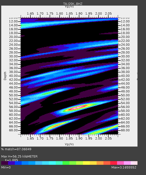
| Estimated Moho Depth: |
56.25 km |
| Estimated Crust Vp/Vs: |
1.88 |
| Assumed Crust Vp: |
6.566 km/s |
| Estimated Crust Vs: |
3.483 km/s |
| Estimated Crust Poisson's Ratio: |
0.30 |
|
| Radial Match: |
87.06849 % |
| Radial Bump: |
400 |
| Transverse Match: |
76.804054 % |
| Transverse Bump: |
400 |
| SOD ConfigId: |
19053131 |
| Insert Time: |
2019-08-10 01:30:47.197 +0000 |
| GWidth: |
2.5 |
| Max Bumps: |
400 |
| Tol: |
0.001 |
|

Signal To Noise
| Channel | StoN | STA | LTA |
| TA:I20K: :BHZ:20190727T01:35:16.699999Z | 2.1436486 | 2.3294072E-7 | 1.0866553E-7 |
| TA:I20K: :BHN:20190727T01:35:16.699999Z | 1.1503304 | 2.713356E-7 | 2.3587624E-7 |
| TA:I20K: :BHE:20190727T01:35:16.699999Z | 1.3793584 | 3.2923444E-7 | 2.3868662E-7 |
| Arrivals |
| Ps | 7.9 SECOND |
| PpPs | 24 SECOND |
| PsPs/PpSs | 32 SECOND |


