You are here: Home > Network List > TA - USArray Transportable Network (new EarthScope stations) Stations List
> Station J26L Joseph Creek, AK, USA > Earthquake Result Viewer
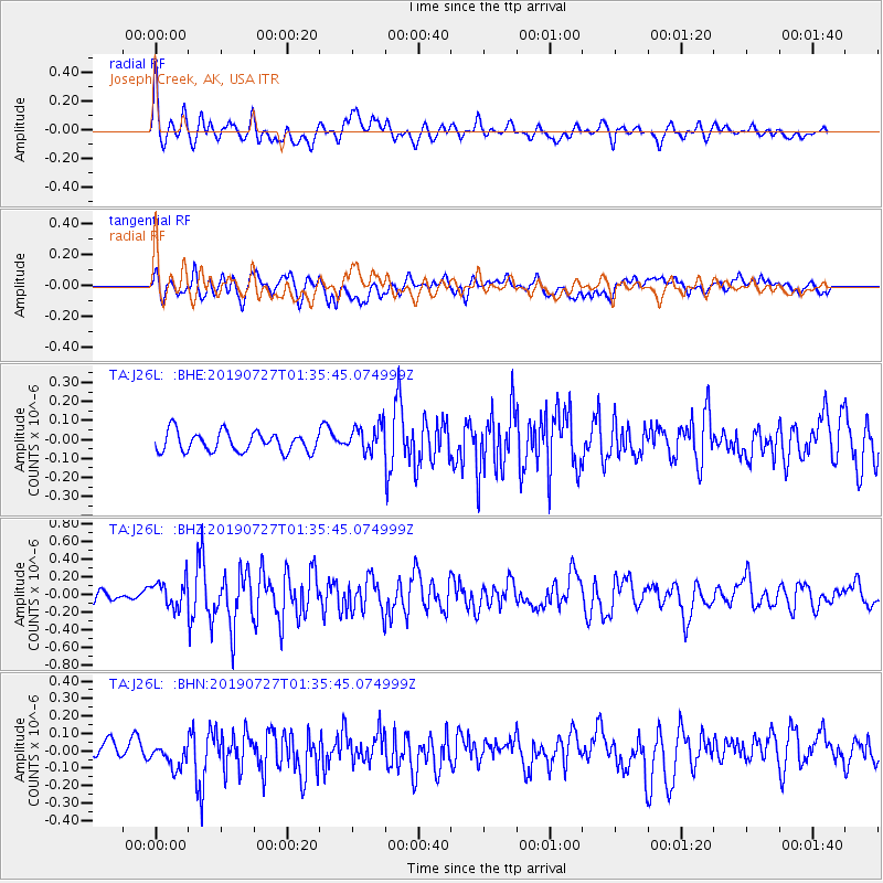
J26L Joseph Creek, AK, USA - Earthquake Result Viewer
*The percent match for this event was below the threshold and hence no stack was calculated.
| Earthquake location: |
Philippine Islands Region |
| Earthquake latitude/longitude: |
20.8/122.0 |
| Earthquake time(UTC): |
2019/07/27 (208) 01:24:44 GMT |
| Earthquake Depth: |
10 km |
| Earthquake Magnitude: |
5.7 Mww |
| Earthquake Catalog/Contributor: |
NEIC PDE/us |
|
| Network: |
TA USArray Transportable Network (new EarthScope stations) |
| Station: |
J26L Joseph Creek, AK, USA |
| Lat/Lon: |
64.50 N/143.56 W |
| Elevation: |
1144 m |
|
| Distance: |
73.3 deg |
| Az: |
26.779 deg |
| Baz: |
283.112 deg |
| Ray Param: |
$rayparam |
*The percent match for this event was below the threshold and hence was not used in the summary stack. |
|
| Radial Match: |
75.986084 % |
| Radial Bump: |
400 |
| Transverse Match: |
63.055874 % |
| Transverse Bump: |
400 |
| SOD ConfigId: |
19053131 |
| Insert Time: |
2019-08-10 01:30:49.752 +0000 |
| GWidth: |
2.5 |
| Max Bumps: |
400 |
| Tol: |
0.001 |
|
Signal To Noise
| Channel | StoN | STA | LTA |
| TA:J26L: :BHZ:20190727T01:35:45.074999Z | 2.007035 | 1.5196473E-7 | 7.571603E-8 |
| TA:J26L: :BHN:20190727T01:35:45.074999Z | 1.6320148 | 6.886537E-8 | 4.2196536E-8 |
| TA:J26L: :BHE:20190727T01:35:45.074999Z | 1.4354811 | 7.373945E-8 | 5.1369152E-8 |
| Arrivals |
| Ps | |
| PpPs | |
| PsPs/PpSs | |


