You are here: Home > Network List > TA - USArray Transportable Network (new EarthScope stations) Stations List
> Station T06C Millerton Lake Dam, Friant, CA, USA > Earthquake Result Viewer
T06C Millerton Lake Dam, Friant, CA, USA - Earthquake Result Viewer

| Earthquake location: |
South Of Fiji Islands |
| Earthquake latitude/longitude: |
-23.6/-180.0 |
| Earthquake time(UTC): |
2006/02/26 (057) 03:08:27 GMT |
| Earthquake Depth: |
535 km |
| Earthquake Magnitude: |
5.9 MB, 6.4 MW, 6.4 MW |
| Earthquake Catalog/Contributor: |
WHDF/NEIC |
|
| Network: |
TA USArray Transportable Network (new EarthScope stations) |
| Station: |
T06C Millerton Lake Dam, Friant, CA, USA |
| Lat/Lon: |
37.01 N/119.71 W |
| Elevation: |
216 m |
|
| Distance: |
82.8 deg |
| Az: |
44.486 deg |
| Baz: |
233.415 deg |
| Ray Param: |
0.04507766 |
| Estimated Moho Depth: |
55.5 km |
| Estimated Crust Vp/Vs: |
1.99 |
| Assumed Crust Vp: |
6.291 km/s |
| Estimated Crust Vs: |
3.161 km/s |
| Estimated Crust Poisson's Ratio: |
0.33 |
|
| Radial Match: |
84.13681 % |
| Radial Bump: |
400 |
| Transverse Match: |
80.941925 % |
| Transverse Bump: |
400 |
| SOD ConfigId: |
2422 |
| Insert Time: |
2010-03-07 02:13:53.255 +0000 |
| GWidth: |
2.5 |
| Max Bumps: |
400 |
| Tol: |
0.001 |
|
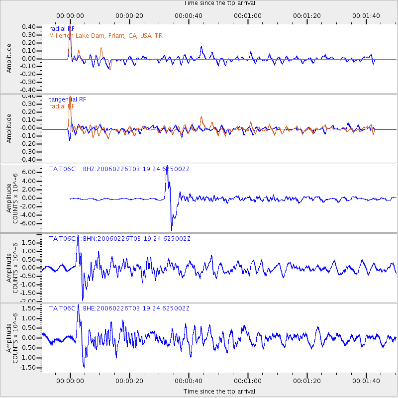
Signal To Noise
| Channel | StoN | STA | LTA |
| TA:T06C: :BHN:20060226T03:19:24.625002Z | 5.692352 | 8.329843E-7 | 1.4633395E-7 |
| TA:T06C: :BHE:20060226T03:19:24.625002Z | 5.7365937 | 7.5416574E-7 | 1.3146578E-7 |
| TA:T06C: :BHZ:20060226T03:19:24.625002Z | 27.311808 | 3.4543868E-6 | 1.2647962E-7 |
| Arrivals |
| Ps | 8.9 SECOND |
| PpPs | 26 SECOND |
| PsPs/PpSs | 35 SECOND |


