You are here: Home > Network List > US - United States National Seismic Network Stations List
> Station ELK Elko, Nevada, USA > Earthquake Result Viewer
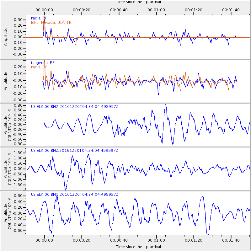
ELK Elko, Nevada, USA - Earthquake Result Viewer
*The percent match for this event was below the threshold and hence no stack was calculated.
| Earthquake location: |
Solomon Islands |
| Earthquake latitude/longitude: |
-10.2/161.2 |
| Earthquake time(UTC): |
2016/12/20 (355) 04:21:28 GMT |
| Earthquake Depth: |
11 km |
| Earthquake Magnitude: |
6.4 mww |
| Earthquake Catalog/Contributor: |
NEIC PDE/us |
|
| Network: |
US United States National Seismic Network |
| Station: |
ELK Elko, Nevada, USA |
| Lat/Lon: |
40.74 N/115.24 W |
| Elevation: |
2210 m |
|
| Distance: |
91.8 deg |
| Az: |
49.053 deg |
| Baz: |
258.108 deg |
| Ray Param: |
$rayparam |
*The percent match for this event was below the threshold and hence was not used in the summary stack. |
|
| Radial Match: |
69.23317 % |
| Radial Bump: |
400 |
| Transverse Match: |
62.872757 % |
| Transverse Bump: |
400 |
| SOD ConfigId: |
1894071 |
| Insert Time: |
2017-01-03 04:23:39.069 +0000 |
| GWidth: |
2.5 |
| Max Bumps: |
400 |
| Tol: |
0.001 |
|
Signal To Noise
| Channel | StoN | STA | LTA |
| US:ELK:00:BHZ:20161220T04:34:04.498997Z | 3.3112946 | 4.5727455E-7 | 1.380954E-7 |
| US:ELK:00:BH1:20161220T04:34:04.498997Z | 2.430126 | 4.0119502E-7 | 1.6509227E-7 |
| US:ELK:00:BH2:20161220T04:34:04.498997Z | 1.2408525 | 2.2889692E-7 | 1.8446747E-7 |
| Arrivals |
| Ps | |
| PpPs | |
| PsPs/PpSs | |


