You are here: Home > Network List > CN - Canadian National Seismograph Network Stations List
> Station INK INUVIK, NT > Earthquake Result Viewer
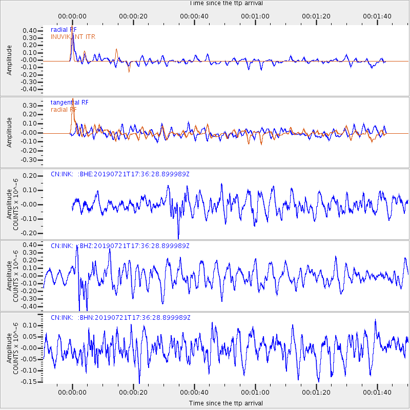
INK INUVIK, NT - Earthquake Result Viewer
*The percent match for this event was below the threshold and hence no stack was calculated.
| Earthquake location: |
South Of Mariana Islands |
| Earthquake latitude/longitude: |
12.3/144.4 |
| Earthquake time(UTC): |
2019/07/21 (202) 17:25:14 GMT |
| Earthquake Depth: |
10 km |
| Earthquake Magnitude: |
5.5 Mww |
| Earthquake Catalog/Contributor: |
NEIC PDE/us |
|
| Network: |
CN Canadian National Seismograph Network |
| Station: |
INK INUVIK, NT |
| Lat/Lon: |
68.31 N/133.53 W |
| Elevation: |
44 m |
|
| Distance: |
75.7 deg |
| Az: |
22.336 deg |
| Baz: |
267.27 deg |
| Ray Param: |
$rayparam |
*The percent match for this event was below the threshold and hence was not used in the summary stack. |
|
| Radial Match: |
74.030106 % |
| Radial Bump: |
400 |
| Transverse Match: |
58.3941 % |
| Transverse Bump: |
400 |
| SOD ConfigId: |
19053131 |
| Insert Time: |
2019-08-10 18:03:53.142 +0000 |
| GWidth: |
2.5 |
| Max Bumps: |
400 |
| Tol: |
0.001 |
|
Signal To Noise
| Channel | StoN | STA | LTA |
| CN:INK: :BHZ:20190721T17:36:28.899989Z | 4.051111 | 2.1483383E-7 | 5.3030842E-8 |
| CN:INK: :BHN:20190721T17:36:28.899989Z | 1.0607598 | 4.2892292E-8 | 4.043544E-8 |
| CN:INK: :BHE:20190721T17:36:28.899989Z | 2.2964358 | 7.600172E-8 | 3.309551E-8 |
| Arrivals |
| Ps | |
| PpPs | |
| PsPs/PpSs | |


