You are here: Home > Network List > TA - USArray Transportable Network (new EarthScope stations) Stations List
> Station R05C Kirkwood Meadows Resort, Kirkwood, CA, USA > Earthquake Result Viewer
R05C Kirkwood Meadows Resort, Kirkwood, CA, USA - Earthquake Result Viewer
| Earthquake location: |
Near Coast Of Peru |
| Earthquake latitude/longitude: |
-13.3/-76.5 |
| Earthquake time(UTC): |
2007/08/16 (228) 00:02:41 GMT |
| Earthquake Depth: |
40 km |
| Earthquake Magnitude: |
5.6 MB |
| Earthquake Catalog/Contributor: |
WHDF/NEIC |
|
| Network: |
TA USArray Transportable Network (new EarthScope stations) |
| Station: |
R05C Kirkwood Meadows Resort, Kirkwood, CA, USA |
| Lat/Lon: |
38.70 N/120.08 W |
| Elevation: |
2366 m |
|
| Distance: |
65.8 deg |
| Az: |
323.74 deg |
| Baz: |
132.607 deg |
| Ray Param: |
0.057964027 |
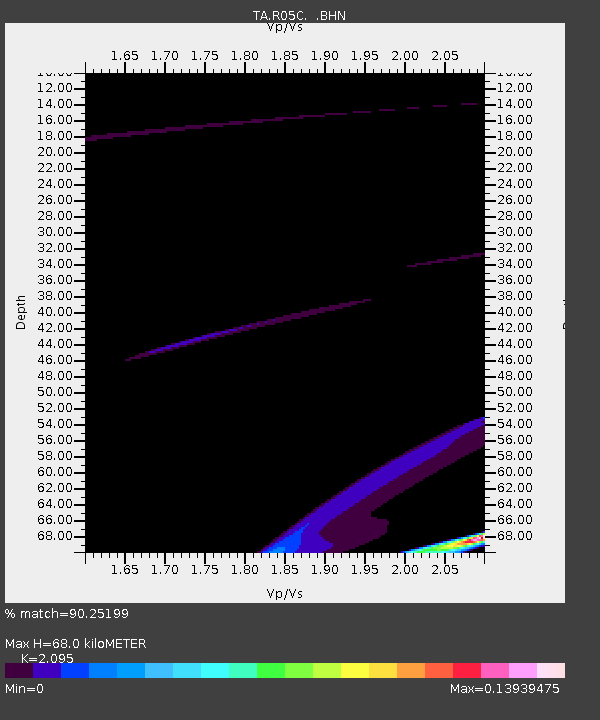
| Estimated Moho Depth: |
68.0 km |
| Estimated Crust Vp/Vs: |
2.10 |
| Assumed Crust Vp: |
6.597 km/s |
| Estimated Crust Vs: |
3.149 km/s |
| Estimated Crust Poisson's Ratio: |
0.35 |
|
| Radial Match: |
90.25199 % |
| Radial Bump: |
275 |
| Transverse Match: |
65.99857 % |
| Transverse Bump: |
221 |
| SOD ConfigId: |
2564 |
| Insert Time: |
2010-03-07 02:15:00.172 +0000 |
| GWidth: |
2.5 |
| Max Bumps: |
400 |
| Tol: |
0.001 |
|

Signal To Noise
| Channel | StoN | STA | LTA |
| TA:R05C: :BHN:20070816T00:12:51.525002Z | 0.1025557 | 3.9614965E-6 | 3.8627757E-5 |
| TA:R05C: :BHE:20070816T00:12:51.525002Z | 0.27897754 | 1.3045339E-5 | 4.676125E-5 |
| TA:R05C: :BHZ:20070816T00:12:51.525002Z | 2.285638 | 3.0894324E-5 | 1.3516717E-5 |
| Arrivals |
| Ps | 12 SECOND |
| PpPs | 31 SECOND |
| PsPs/PpSs | 42 SECOND |


