You are here: Home > Network List > TA - USArray Transportable Network (new EarthScope stations) Stations List
> Station R05C Kirkwood Meadows Resort, Kirkwood, CA, USA > Earthquake Result Viewer
R05C Kirkwood Meadows Resort, Kirkwood, CA, USA - Earthquake Result Viewer
| Earthquake location: |
Kuril Islands |
| Earthquake latitude/longitude: |
46.6/153.3 |
| Earthquake time(UTC): |
2006/11/15 (319) 11:14:13 GMT |
| Earthquake Depth: |
10 km |
| Earthquake Magnitude: |
6.5 MB, 7.8 MS, 8.3 MW, 7.9 MW |
| Earthquake Catalog/Contributor: |
WHDF/NEIC |
|
| Network: |
TA USArray Transportable Network (new EarthScope stations) |
| Station: |
R05C Kirkwood Meadows Resort, Kirkwood, CA, USA |
| Lat/Lon: |
38.70 N/120.08 W |
| Elevation: |
2366 m |
|
| Distance: |
61.2 deg |
| Az: |
63.092 deg |
| Baz: |
308.192 deg |
| Ray Param: |
0.06105687 |
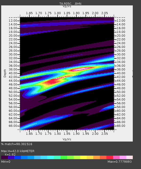
| Estimated Moho Depth: |
42.0 km |
| Estimated Crust Vp/Vs: |
1.82 |
| Assumed Crust Vp: |
6.597 km/s |
| Estimated Crust Vs: |
3.625 km/s |
| Estimated Crust Poisson's Ratio: |
0.28 |
|
| Radial Match: |
98.381516 % |
| Radial Bump: |
226 |
| Transverse Match: |
96.4287 % |
| Transverse Bump: |
368 |
| SOD ConfigId: |
2564 |
| Insert Time: |
2010-03-07 02:15:49.465 +0000 |
| GWidth: |
2.5 |
| Max Bumps: |
400 |
| Tol: |
0.001 |
|

Signal To Noise
| Channel | StoN | STA | LTA |
| TA:R05C: :BHN:20061115T11:23:56.999016Z | 3.3021083 | 4.3165986E-7 | 1.307225E-7 |
| TA:R05C: :BHE:20061115T11:23:56.999016Z | 3.6900082 | 5.695639E-7 | 1.5435302E-7 |
| TA:R05C: :BHZ:20061115T11:23:56.999016Z | 4.7793145 | 1.2122293E-6 | 2.5364082E-7 |
| Arrivals |
| Ps | 5.5 SECOND |
| PpPs | 17 SECOND |
| PsPs/PpSs | 23 SECOND |


