You are here: Home > Network List > TA - USArray Transportable Network (new EarthScope stations) Stations List
> Station O17K Koliganek, Bristol Bay, AK, USA > Earthquake Result Viewer
O17K Koliganek, Bristol Bay, AK, USA - Earthquake Result Viewer
| Earthquake location: |
South Of Mariana Islands |
| Earthquake latitude/longitude: |
12.3/144.4 |
| Earthquake time(UTC): |
2019/07/21 (202) 17:25:14 GMT |
| Earthquake Depth: |
10 km |
| Earthquake Magnitude: |
5.5 Mww |
| Earthquake Catalog/Contributor: |
NEIC PDE/us |
|
| Network: |
TA USArray Transportable Network (new EarthScope stations) |
| Station: |
O17K Koliganek, Bristol Bay, AK, USA |
| Lat/Lon: |
59.77 N/157.09 W |
| Elevation: |
156 m |
|
| Distance: |
63.8 deg |
| Az: |
28.738 deg |
| Baz: |
248.221 deg |
| Ray Param: |
0.059340402 |
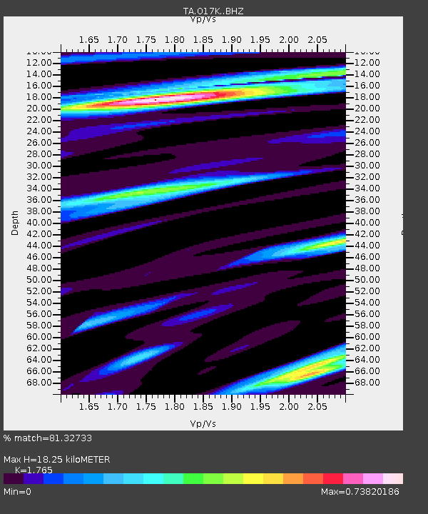
| Estimated Moho Depth: |
18.25 km |
| Estimated Crust Vp/Vs: |
1.76 |
| Assumed Crust Vp: |
6.276 km/s |
| Estimated Crust Vs: |
3.556 km/s |
| Estimated Crust Poisson's Ratio: |
0.26 |
|
| Radial Match: |
81.32733 % |
| Radial Bump: |
400 |
| Transverse Match: |
60.80141 % |
| Transverse Bump: |
400 |
| SOD ConfigId: |
19053131 |
| Insert Time: |
2019-08-10 18:07:25.724 +0000 |
| GWidth: |
2.5 |
| Max Bumps: |
400 |
| Tol: |
0.001 |
|
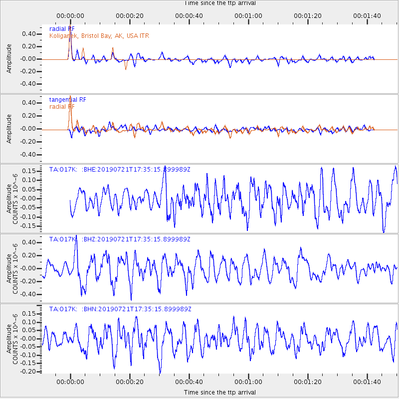
Signal To Noise
| Channel | StoN | STA | LTA |
| TA:O17K: :BHZ:20190721T17:35:15.899989Z | 3.9660854 | 2.4464077E-7 | 6.168318E-8 |
| TA:O17K: :BHN:20190721T17:35:15.899989Z | 1.4102734 | 4.972669E-8 | 3.5260317E-8 |
| TA:O17K: :BHE:20190721T17:35:15.899989Z | 1.9528053 | 8.52188E-8 | 4.363917E-8 |
| Arrivals |
| Ps | 2.3 SECOND |
| PpPs | 7.7 SECOND |
| PsPs/PpSs | 10 SECOND |


