You are here: Home > Network List > TA - USArray Transportable Network (new EarthScope stations) Stations List
> Station R32K Eaglecrest, AK, USA > Earthquake Result Viewer
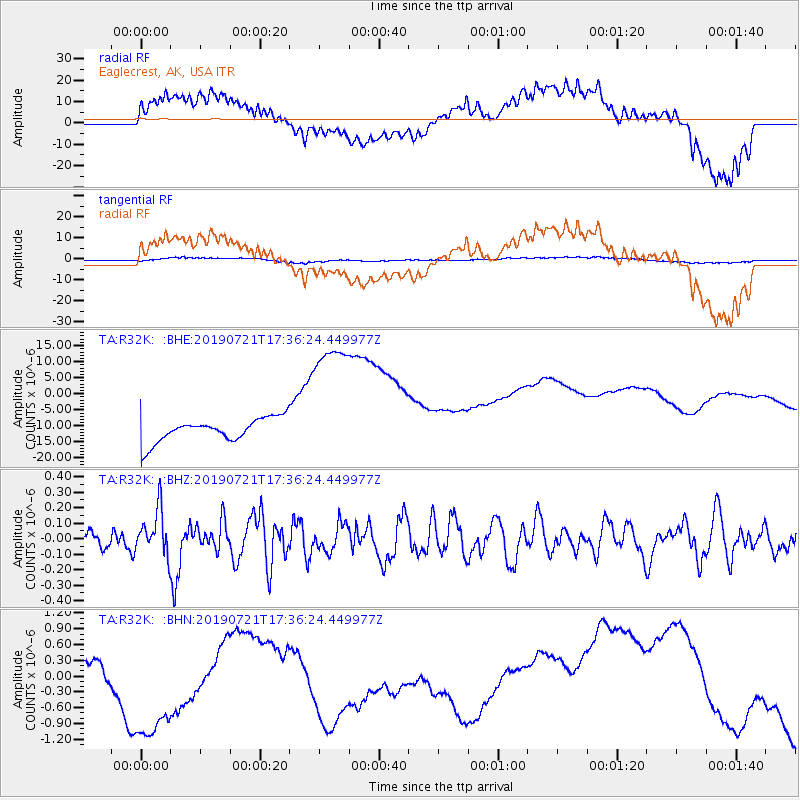
R32K Eaglecrest, AK, USA - Earthquake Result Viewer
*The percent match for this event was below the threshold and hence no stack was calculated.
| Earthquake location: |
South Of Mariana Islands |
| Earthquake latitude/longitude: |
12.3/144.4 |
| Earthquake time(UTC): |
2019/07/21 (202) 17:25:14 GMT |
| Earthquake Depth: |
10 km |
| Earthquake Magnitude: |
5.5 Mww |
| Earthquake Catalog/Contributor: |
NEIC PDE/us |
|
| Network: |
TA USArray Transportable Network (new EarthScope stations) |
| Station: |
R32K Eaglecrest, AK, USA |
| Lat/Lon: |
58.27 N/134.52 W |
| Elevation: |
386 m |
|
| Distance: |
74.9 deg |
| Az: |
32.729 deg |
| Baz: |
269.026 deg |
| Ray Param: |
$rayparam |
*The percent match for this event was below the threshold and hence was not used in the summary stack. |
|
| Radial Match: |
67.11518 % |
| Radial Bump: |
400 |
| Transverse Match: |
39.814793 % |
| Transverse Bump: |
400 |
| SOD ConfigId: |
19053131 |
| Insert Time: |
2019-08-10 18:07:36.546 +0000 |
| GWidth: |
2.5 |
| Max Bumps: |
400 |
| Tol: |
0.001 |
|
Signal To Noise
| Channel | StoN | STA | LTA |
| TA:R32K: :BHZ:20190721T17:36:24.449977Z | 2.595058 | 1.4967128E-7 | 5.7675503E-8 |
| TA:R32K: :BHN:20190721T17:36:24.449977Z | 4.832898 | 1.7978043E-6 | 3.71993E-7 |
| TA:R32K: :BHE:20190721T17:36:24.449977Z | 6.299507 | 2.299416E-5 | 3.650152E-6 |
| Arrivals |
| Ps | |
| PpPs | |
| PsPs/PpSs | |


