You are here: Home > Network List > TA - USArray Transportable Network (new EarthScope stations) Stations List
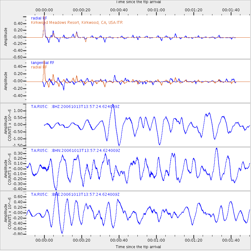
> Station R05C Kirkwood Meadows Resort, Kirkwood, CA, USA > Earthquake Result Viewer
R05C Kirkwood Meadows Resort, Kirkwood, CA, USA - Earthquake Result Viewer
| Earthquake location: |
Kuril Islands |
| Earthquake latitude/longitude: |
46.3/153.3 |
| Earthquake time(UTC): |
2006/10/13 (286) 13:47:39 GMT |
| Earthquake Depth: |
8.0 km |
| Earthquake Magnitude: |
5.5 MB, 5.8 MS, 6.3 MW, 5.8 MW |
| Earthquake Catalog/Contributor: |
WHDF/NEIC |
|
| Network: |
TA USArray Transportable Network (new EarthScope stations) |
| Station: |
R05C Kirkwood Meadows Resort, Kirkwood, CA, USA |
| Lat/Lon: |
38.70 N/120.08 W |
| Elevation: |
2366 m |
|
| Distance: |
61.3 deg |
| Az: |
62.933 deg |
| Baz: |
307.841 deg |
| Ray Param: |
0.06096462 |
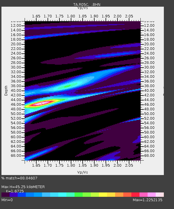
| Estimated Moho Depth: |
45.25 km |
| Estimated Crust Vp/Vs: |
1.67 |
| Assumed Crust Vp: |
6.597 km/s |
| Estimated Crust Vs: |
3.945 km/s |
| Estimated Crust Poisson's Ratio: |
0.22 |
|
| Radial Match: |
88.84607 % |
| Radial Bump: |
268 |
| Transverse Match: |
77.7943 % |
| Transverse Bump: |
400 |
| SOD ConfigId: |
2665 |
| Insert Time: |
2010-03-07 02:16:03.115 +0000 |
| GWidth: |
2.5 |
| Max Bumps: |
400 |
| Tol: |
0.001 |
|
Signal To Noise
| Channel | StoN | STA | LTA |
| TA:R05C: :BHN:20061013T13:57:24.624009Z | 1.1750823 | 9.276722E-8 | 7.894529E-8 |
| TA:R05C: :BHE:20061013T13:57:24.624009Z | 3.2307317 | 2.3106614E-7 | 7.15213E-8 |
| TA:R05C: :BHZ:20061013T13:57:24.624009Z | 3.32654 | 5.2500025E-7 | 1.5782172E-7 |
| Arrivals |
| Ps | 4.9 SECOND |
| PpPs | 17 SECOND |
| PsPs/PpSs | 22 SECOND |


