You are here: Home > Network List > US - United States National Seismic Network Stations List
> Station HAWA Hanford, Washington, USA > Earthquake Result Viewer
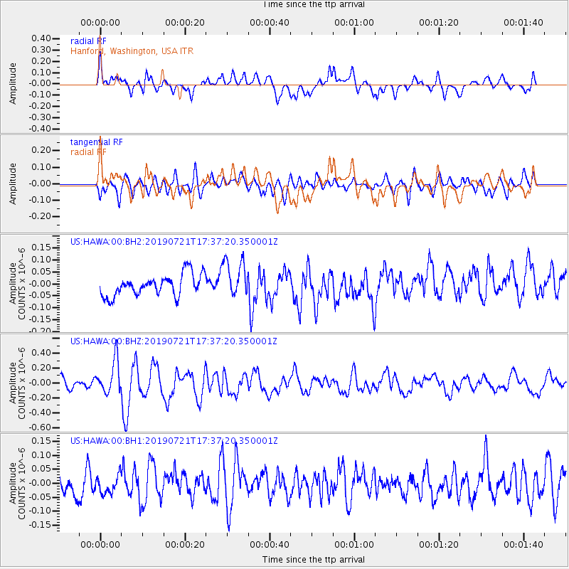
HAWA Hanford, Washington, USA - Earthquake Result Viewer
*The percent match for this event was below the threshold and hence no stack was calculated.
| Earthquake location: |
South Of Mariana Islands |
| Earthquake latitude/longitude: |
12.3/144.4 |
| Earthquake time(UTC): |
2019/07/21 (202) 17:25:14 GMT |
| Earthquake Depth: |
10 km |
| Earthquake Magnitude: |
5.5 Mww |
| Earthquake Catalog/Contributor: |
NEIC PDE/us |
|
| Network: |
US United States National Seismic Network |
| Station: |
HAWA Hanford, Washington, USA |
| Lat/Lon: |
46.39 N/119.53 W |
| Elevation: |
364 m |
|
| Distance: |
85.3 deg |
| Az: |
43.676 deg |
| Baz: |
282.842 deg |
| Ray Param: |
$rayparam |
*The percent match for this event was below the threshold and hence was not used in the summary stack. |
|
| Radial Match: |
62.591915 % |
| Radial Bump: |
400 |
| Transverse Match: |
60.820923 % |
| Transverse Bump: |
400 |
| SOD ConfigId: |
19053131 |
| Insert Time: |
2019-08-10 18:07:59.624 +0000 |
| GWidth: |
2.5 |
| Max Bumps: |
400 |
| Tol: |
0.001 |
|
Signal To Noise
| Channel | StoN | STA | LTA |
| US:HAWA:00:BHZ:20190721T17:37:20.350001Z | 3.4587536 | 2.2853533E-7 | 6.607447E-8 |
| US:HAWA:00:BH1:20190721T17:37:20.350001Z | 0.7835857 | 3.2475842E-8 | 4.144517E-8 |
| US:HAWA:00:BH2:20190721T17:37:20.350001Z | 1.7436974 | 7.795208E-8 | 4.4705054E-8 |
| Arrivals |
| Ps | |
| PpPs | |
| PsPs/PpSs | |


