You are here: Home > Network List > TA - USArray Transportable Network (new EarthScope stations) Stations List
> Station R05C Kirkwood Meadows Resort, Kirkwood, CA, USA > Earthquake Result Viewer
R05C Kirkwood Meadows Resort, Kirkwood, CA, USA - Earthquake Result Viewer
| Earthquake location: |
Gulf Of Mexico |
| Earthquake latitude/longitude: |
26.3/-86.6 |
| Earthquake time(UTC): |
2006/09/10 (253) 14:56:08 GMT |
| Earthquake Depth: |
14 km |
| Earthquake Magnitude: |
5.9 MB, 5.5 MS, 5.8 MW, 5.8 MW |
| Earthquake Catalog/Contributor: |
WHDF/NEIC |
|
| Network: |
TA USArray Transportable Network (new EarthScope stations) |
| Station: |
R05C Kirkwood Meadows Resort, Kirkwood, CA, USA |
| Lat/Lon: |
38.70 N/120.08 W |
| Elevation: |
2366 m |
|
| Distance: |
30.6 deg |
| Az: |
302.137 deg |
| Baz: |
103.757 deg |
| Ray Param: |
0.07927494 |
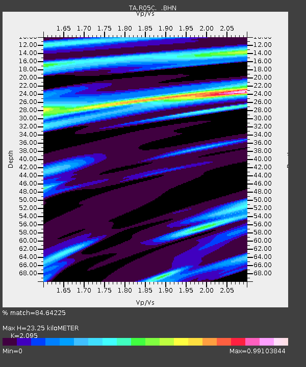
| Estimated Moho Depth: |
23.25 km |
| Estimated Crust Vp/Vs: |
2.10 |
| Assumed Crust Vp: |
6.597 km/s |
| Estimated Crust Vs: |
3.149 km/s |
| Estimated Crust Poisson's Ratio: |
0.35 |
|
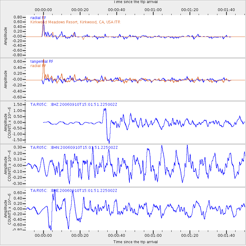
| Radial Match: |
84.64225 % |
| Radial Bump: |
400 |
| Transverse Match: |
73.32425 % |
| Transverse Bump: |
400 |
| SOD ConfigId: |
2665 |
| Insert Time: |
2010-03-07 02:16:13.719 +0000 |
| GWidth: |
2.5 |
| Max Bumps: |
400 |
| Tol: |
0.001 |
|
Signal To Noise
| Channel | StoN | STA | LTA |
| TA:R05C: :BHN:20060910T15:01:51.225002Z | 2.4566333 | 1.0618105E-7 | 4.322218E-8 |
| TA:R05C: :BHE:20060910T15:01:51.225002Z | 4.0946746 | 3.762568E-7 | 9.1889305E-8 |
| TA:R05C: :BHZ:20060910T15:01:51.225002Z | 8.112674 | 6.159736E-7 | 7.592732E-8 |
| Arrivals |
| Ps | 4.1 SECOND |
| PpPs | 10 SECOND |
| PsPs/PpSs | 14 SECOND |


