You are here: Home > Network List > TA - USArray Transportable Network (new EarthScope stations) Stations List
> Station R05C Kirkwood Meadows Resort, Kirkwood, CA, USA > Earthquake Result Viewer
R05C Kirkwood Meadows Resort, Kirkwood, CA, USA - Earthquake Result Viewer

| Earthquake location: |
Chile-Argentina Border Region |
| Earthquake latitude/longitude: |
-24.4/-67.0 |
| Earthquake time(UTC): |
2006/08/25 (237) 00:44:46 GMT |
| Earthquake Depth: |
184 km |
| Earthquake Magnitude: |
5.9 MB, 6.6 MW, 6.6 MW |
| Earthquake Catalog/Contributor: |
WHDF/NEIC |
|
| Network: |
TA USArray Transportable Network (new EarthScope stations) |
| Station: |
R05C Kirkwood Meadows Resort, Kirkwood, CA, USA |
| Lat/Lon: |
38.70 N/120.08 W |
| Elevation: |
2366 m |
|
| Distance: |
80.0 deg |
| Az: |
320.591 deg |
| Baz: |
132.293 deg |
| Ray Param: |
0.048098654 |
| Estimated Moho Depth: |
42.25 km |
| Estimated Crust Vp/Vs: |
1.76 |
| Assumed Crust Vp: |
6.597 km/s |
| Estimated Crust Vs: |
3.754 km/s |
| Estimated Crust Poisson's Ratio: |
0.26 |
|
| Radial Match: |
90.83599 % |
| Radial Bump: |
400 |
| Transverse Match: |
79.53414 % |
| Transverse Bump: |
400 |
| SOD ConfigId: |
2665 |
| Insert Time: |
2010-03-07 02:16:16.475 +0000 |
| GWidth: |
2.5 |
| Max Bumps: |
400 |
| Tol: |
0.001 |
|
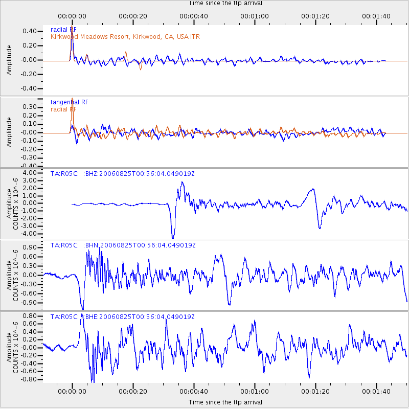
Signal To Noise
| Channel | StoN | STA | LTA |
| TA:R05C: :BHN:20060825T00:56:04.049019Z | 7.6056147 | 5.1847394E-7 | 6.8169896E-8 |
| TA:R05C: :BHE:20060825T00:56:04.049019Z | 6.805863 | 3.7503582E-7 | 5.5104817E-8 |
| TA:R05C: :BHZ:20060825T00:56:04.049019Z | 23.092302 | 2.032463E-6 | 8.8014744E-8 |
| Arrivals |
| Ps | 5.0 SECOND |
| PpPs | 17 SECOND |
| PsPs/PpSs | 22 SECOND |


