You are here: Home > Network List > TA - USArray Transportable Network (new EarthScope stations) Stations List
> Station R05C Kirkwood Meadows Resort, Kirkwood, CA, USA > Earthquake Result Viewer
R05C Kirkwood Meadows Resort, Kirkwood, CA, USA - Earthquake Result Viewer
| Earthquake location: |
East Of Kuril Islands |
| Earthquake latitude/longitude: |
46.2/154.4 |
| Earthquake time(UTC): |
2006/12/07 (341) 19:10:21 GMT |
| Earthquake Depth: |
16 km |
| Earthquake Magnitude: |
6.3 MB, 6.1 MS, 6.3 MW, 6.3 MW |
| Earthquake Catalog/Contributor: |
WHDF/NEIC |
|
| Network: |
TA USArray Transportable Network (new EarthScope stations) |
| Station: |
R05C Kirkwood Meadows Resort, Kirkwood, CA, USA |
| Lat/Lon: |
38.70 N/120.08 W |
| Elevation: |
2366 m |
|
| Distance: |
60.7 deg |
| Az: |
63.488 deg |
| Baz: |
307.344 deg |
| Ray Param: |
0.06137077 |
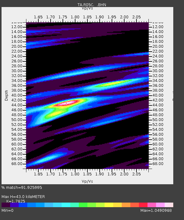
| Estimated Moho Depth: |
43.0 km |
| Estimated Crust Vp/Vs: |
1.76 |
| Assumed Crust Vp: |
6.597 km/s |
| Estimated Crust Vs: |
3.743 km/s |
| Estimated Crust Poisson's Ratio: |
0.26 |
|
| Radial Match: |
91.925995 % |
| Radial Bump: |
329 |
| Transverse Match: |
83.87605 % |
| Transverse Bump: |
400 |
| SOD ConfigId: |
2564 |
| Insert Time: |
2010-03-07 02:16:43.080 +0000 |
| GWidth: |
2.5 |
| Max Bumps: |
400 |
| Tol: |
0.001 |
|
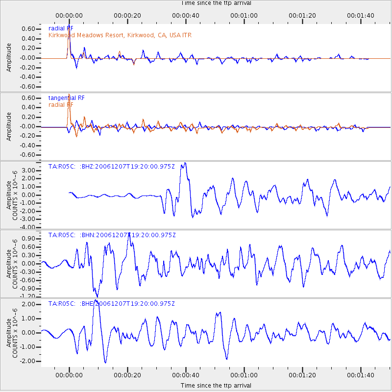
Signal To Noise
| Channel | StoN | STA | LTA |
| TA:R05C: :BHN:20061207T19:20:00.975Z | 1.6640514 | 1.9909251E-7 | 1.1964325E-7 |
| TA:R05C: :BHE:20061207T19:20:00.975Z | 2.8172772 | 5.641737E-7 | 2.0025496E-7 |
| TA:R05C: :BHZ:20061207T19:20:00.975Z | 4.8268886 | 8.1810964E-7 | 1.6949006E-7 |
| Arrivals |
| Ps | 5.2 SECOND |
| PpPs | 17 SECOND |
| PsPs/PpSs | 22 SECOND |


