You are here: Home > Network List > TA - USArray Transportable Network (new EarthScope stations) Stations List
> Station F05A White Salmon, WA, USA > Earthquake Result Viewer
F05A White Salmon, WA, USA - Earthquake Result Viewer

| Earthquake location: |
Fiji Islands Region |
| Earthquake latitude/longitude: |
-15.3/-178.6 |
| Earthquake time(UTC): |
2005/12/13 (347) 03:16:06 GMT |
| Earthquake Depth: |
10 km |
| Earthquake Magnitude: |
6.1 MB, 6.8 MS, 6.7 MW, 6.7 MW |
| Earthquake Catalog/Contributor: |
WHDF/NEIC |
|
| Network: |
TA USArray Transportable Network (new EarthScope stations) |
| Station: |
F05A White Salmon, WA, USA |
| Lat/Lon: |
45.88 N/121.46 W |
| Elevation: |
455 m |
|
| Distance: |
79.7 deg |
| Az: |
36.597 deg |
| Baz: |
235.464 deg |
| Ray Param: |
0.04878323 |
| Estimated Moho Depth: |
33.75 km |
| Estimated Crust Vp/Vs: |
1.65 |
| Assumed Crust Vp: |
6.597 km/s |
| Estimated Crust Vs: |
3.986 km/s |
| Estimated Crust Poisson's Ratio: |
0.21 |
|
| Radial Match: |
90.93569 % |
| Radial Bump: |
400 |
| Transverse Match: |
85.64751 % |
| Transverse Bump: |
400 |
| SOD ConfigId: |
2564 |
| Insert Time: |
2010-03-07 02:16:49.088 +0000 |
| GWidth: |
2.5 |
| Max Bumps: |
400 |
| Tol: |
0.001 |
|
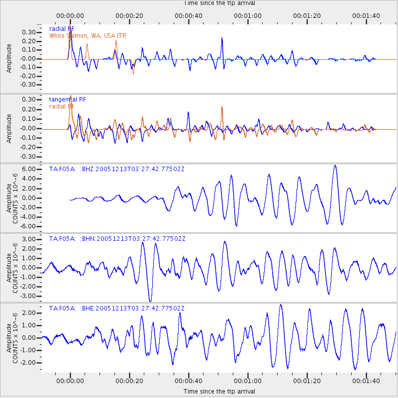
Signal To Noise
| Channel | StoN | STA | LTA |
| TA:F05A: :BHN:20051213T03:27:42.77502Z | 1.4183012 | 4.3510937E-7 | 3.0678206E-7 |
| TA:F05A: :BHE:20051213T03:27:42.77502Z | 1.7348115 | 2.604511E-7 | 1.501322E-7 |
| TA:F05A: :BHZ:20051213T03:27:42.77502Z | 3.540942 | 1.3008205E-6 | 3.6736566E-7 |
| Arrivals |
| Ps | 3.5 SECOND |
| PpPs | 13 SECOND |
| PsPs/PpSs | 17 SECOND |


