You are here: Home > Network List > TA - USArray Transportable Network (new EarthScope stations) Stations List
> Station F05A White Salmon, WA, USA > Earthquake Result Viewer
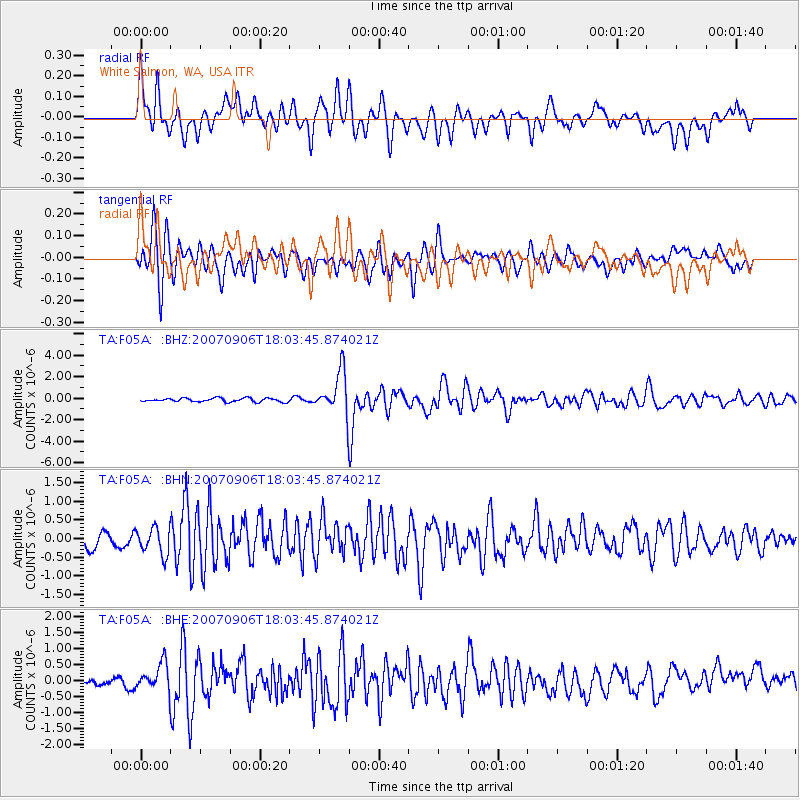
F05A White Salmon, WA, USA - Earthquake Result Viewer

| Earthquake location: |
Taiwan Region |
| Earthquake latitude/longitude: |
24.3/122.2 |
| Earthquake time(UTC): |
2007/09/06 (249) 17:51:26 GMT |
| Earthquake Depth: |
53 km |
| Earthquake Magnitude: |
6.1 MB, 6.2 MW, 6.1 ME |
| Earthquake Catalog/Contributor: |
WHDF/NEIC |
|
| Network: |
TA USArray Transportable Network (new EarthScope stations) |
| Station: |
F05A White Salmon, WA, USA |
| Lat/Lon: |
45.88 N/121.46 W |
| Elevation: |
455 m |
|
| Distance: |
89.4 deg |
| Az: |
38.765 deg |
| Baz: |
305.153 deg |
| Ray Param: |
0.041802682 |
| Estimated Moho Depth: |
67.75 km |
| Estimated Crust Vp/Vs: |
2.06 |
| Assumed Crust Vp: |
6.597 km/s |
| Estimated Crust Vs: |
3.199 km/s |
| Estimated Crust Poisson's Ratio: |
0.35 |
|
| Radial Match: |
80.59783 % |
| Radial Bump: |
400 |
| Transverse Match: |
79.904724 % |
| Transverse Bump: |
400 |
| SOD ConfigId: |
2564 |
| Insert Time: |
2010-03-07 02:17:06.549 +0000 |
| GWidth: |
2.5 |
| Max Bumps: |
400 |
| Tol: |
0.001 |
|
Signal To Noise
| Channel | StoN | STA | LTA |
| TA:F05A: :BHN:20070906T18:03:45.874021Z | 1.8524085 | 3.560271E-7 | 1.9219686E-7 |
| TA:F05A: :BHE:20070906T18:03:45.874021Z | 2.9035532 | 4.0855267E-7 | 1.4070783E-7 |
| TA:F05A: :BHZ:20070906T18:03:45.874021Z | 11.617916 | 1.9799372E-6 | 1.7042103E-7 |
| Arrivals |
| Ps | 11 SECOND |
| PpPs | 31 SECOND |
| PsPs/PpSs | 42 SECOND |


