You are here: Home > Network List > TA - USArray Transportable Network (new EarthScope stations) Stations List
> Station F05A White Salmon, WA, USA > Earthquake Result Viewer
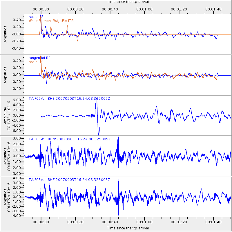
F05A White Salmon, WA, USA - Earthquake Result Viewer

| Earthquake location: |
Kuril Islands |
| Earthquake latitude/longitude: |
45.8/150.1 |
| Earthquake time(UTC): |
2007/09/03 (246) 16:14:53 GMT |
| Earthquake Depth: |
94 km |
| Earthquake Magnitude: |
6.3 MB, 6.2 MW, 6.2 ME |
| Earthquake Catalog/Contributor: |
WHDF/NEIC |
|
| Network: |
TA USArray Transportable Network (new EarthScope stations) |
| Station: |
F05A White Salmon, WA, USA |
| Lat/Lon: |
45.88 N/121.46 W |
| Elevation: |
455 m |
|
| Distance: |
58.4 deg |
| Az: |
55.104 deg |
| Baz: |
304.825 deg |
| Ray Param: |
0.06262677 |
| Estimated Moho Depth: |
10.75 km |
| Estimated Crust Vp/Vs: |
1.62 |
| Assumed Crust Vp: |
6.597 km/s |
| Estimated Crust Vs: |
4.079 km/s |
| Estimated Crust Poisson's Ratio: |
0.19 |
|
| Radial Match: |
88.97882 % |
| Radial Bump: |
400 |
| Transverse Match: |
80.640785 % |
| Transverse Bump: |
400 |
| SOD ConfigId: |
2564 |
| Insert Time: |
2010-03-07 02:17:08.088 +0000 |
| GWidth: |
2.5 |
| Max Bumps: |
400 |
| Tol: |
0.001 |
|
Signal To Noise
| Channel | StoN | STA | LTA |
| TA:F05A: :BHN:20070903T16:24:08.325005Z | 6.30582 | 1.0216252E-6 | 1.6201305E-7 |
| TA:F05A: :BHE:20070903T16:24:08.325005Z | 8.169637 | 1.465613E-6 | 1.7939756E-7 |
| TA:F05A: :BHZ:20070903T16:24:08.325005Z | 23.20169 | 3.833668E-6 | 1.6523228E-7 |
| Arrivals |
| Ps | 1.1 SECOND |
| PpPs | 4.0 SECOND |
| PsPs/PpSs | 5.1 SECOND |


