You are here: Home > Network List > TA - USArray Transportable Network (new EarthScope stations) Stations List
> Station F05A White Salmon, WA, USA > Earthquake Result Viewer
F05A White Salmon, WA, USA - Earthquake Result Viewer

| Earthquake location: |
Solomon Islands |
| Earthquake latitude/longitude: |
-9.8/159.5 |
| Earthquake time(UTC): |
2007/08/16 (228) 08:39:27 GMT |
| Earthquake Depth: |
10 km |
| Earthquake Magnitude: |
6.1 MB, 6.7 MS, 6.4 MW |
| Earthquake Catalog/Contributor: |
WHDF/NEIC |
|
| Network: |
TA USArray Transportable Network (new EarthScope stations) |
| Station: |
F05A White Salmon, WA, USA |
| Lat/Lon: |
45.88 N/121.46 W |
| Elevation: |
455 m |
|
| Distance: |
89.5 deg |
| Az: |
43.305 deg |
| Baz: |
255.395 deg |
| Ray Param: |
0.04182058 |
| Estimated Moho Depth: |
17.75 km |
| Estimated Crust Vp/Vs: |
2.10 |
| Assumed Crust Vp: |
6.597 km/s |
| Estimated Crust Vs: |
3.145 km/s |
| Estimated Crust Poisson's Ratio: |
0.35 |
|
| Radial Match: |
92.92903 % |
| Radial Bump: |
400 |
| Transverse Match: |
91.20543 % |
| Transverse Bump: |
400 |
| SOD ConfigId: |
2564 |
| Insert Time: |
2010-03-07 02:17:11.396 +0000 |
| GWidth: |
2.5 |
| Max Bumps: |
400 |
| Tol: |
0.001 |
|
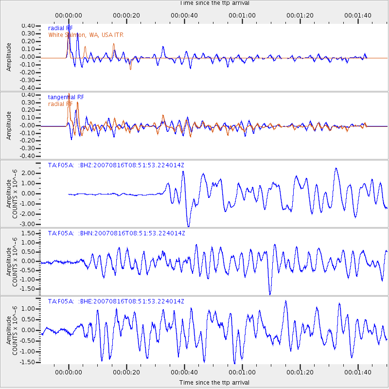
Signal To Noise
| Channel | StoN | STA | LTA |
| TA:F05A: :BHN:20070816T08:51:53.224014Z | 0.91416335 | 6.838372E-8 | 7.48047E-8 |
| TA:F05A: :BHE:20070816T08:51:53.224014Z | 2.5580773 | 1.621661E-7 | 6.339374E-8 |
| TA:F05A: :BHZ:20070816T08:51:53.224014Z | 8.81377 | 4.5808716E-7 | 5.1974027E-8 |
| Arrivals |
| Ps | 3.0 SECOND |
| PpPs | 8.2 SECOND |
| PsPs/PpSs | 11 SECOND |


