You are here: Home > Network List > AV - Alaska Volcano Observatory Stations List
> Station SPCG Capps Glacier, Mount Spurr, Alaska > Earthquake Result Viewer
SPCG Capps Glacier, Mount Spurr, Alaska - Earthquake Result Viewer
| Earthquake location: |
Near S. Coast Of Honshu, Japan |
| Earthquake latitude/longitude: |
33.1/137.3 |
| Earthquake time(UTC): |
2019/07/27 (208) 18:31:07 GMT |
| Earthquake Depth: |
367 km |
| Earthquake Magnitude: |
6.3 Mww |
| Earthquake Catalog/Contributor: |
NEIC PDE/us |
|
| Network: |
AV Alaska Volcano Observatory |
| Station: |
SPCG Capps Glacier, Mount Spurr, Alaska |
| Lat/Lon: |
61.29 N/152.02 W |
| Elevation: |
1329 m |
|
| Distance: |
52.4 deg |
| Az: |
35.124 deg |
| Baz: |
271.403 deg |
| Ray Param: |
0.06536824 |
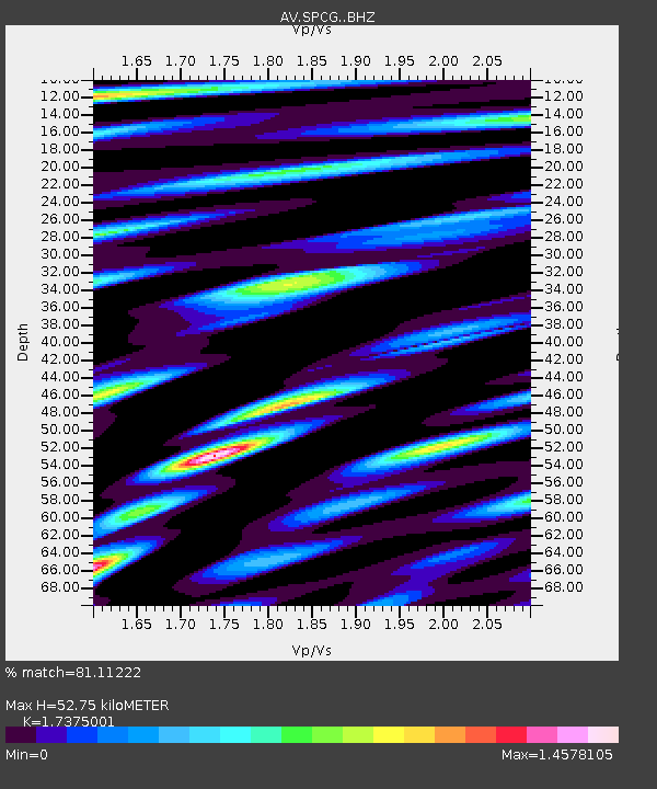
| Estimated Moho Depth: |
52.75 km |
| Estimated Crust Vp/Vs: |
1.74 |
| Assumed Crust Vp: |
6.566 km/s |
| Estimated Crust Vs: |
3.779 km/s |
| Estimated Crust Poisson's Ratio: |
0.25 |
|
| Radial Match: |
81.11222 % |
| Radial Bump: |
400 |
| Transverse Match: |
81.662544 % |
| Transverse Bump: |
400 |
| SOD ConfigId: |
19053131 |
| Insert Time: |
2019-08-10 18:34:01.586 +0000 |
| GWidth: |
2.5 |
| Max Bumps: |
400 |
| Tol: |
0.001 |
|

Signal To Noise
| Channel | StoN | STA | LTA |
| AV:SPCG: :BHZ:20190727T18:39:12.58001Z | 24.43426 | 3.527507E-6 | 1.4436725E-7 |
| AV:SPCG: :BHN:20190727T18:39:12.58001Z | 6.0206656 | 1.0084976E-6 | 1.6750599E-7 |
| AV:SPCG: :BHE:20190727T18:39:12.58001Z | 8.3186035 | 9.4737965E-7 | 1.1388686E-7 |
| Arrivals |
| Ps | 6.3 SECOND |
| PpPs | 21 SECOND |
| PsPs/PpSs | 27 SECOND |


