You are here: Home > Network List > AV - Alaska Volcano Observatory Stations List
> Station ETKA Kagalaska Island, Regional Station, Alaska > Earthquake Result Viewer
ETKA Kagalaska Island, Regional Station, Alaska - Earthquake Result Viewer
| Earthquake location: |
Near S. Coast Of Honshu, Japan |
| Earthquake latitude/longitude: |
33.1/137.3 |
| Earthquake time(UTC): |
2019/07/27 (208) 18:31:07 GMT |
| Earthquake Depth: |
367 km |
| Earthquake Magnitude: |
6.3 Mww |
| Earthquake Catalog/Contributor: |
NEIC PDE/us |
|
| Network: |
AV Alaska Volcano Observatory |
| Station: |
ETKA Kagalaska Island, Regional Station, Alaska |
| Lat/Lon: |
51.86 N/176.41 W |
| Elevation: |
290 m |
|
| Distance: |
38.1 deg |
| Az: |
46.525 deg |
| Baz: |
259.031 deg |
| Ray Param: |
0.07417135 |
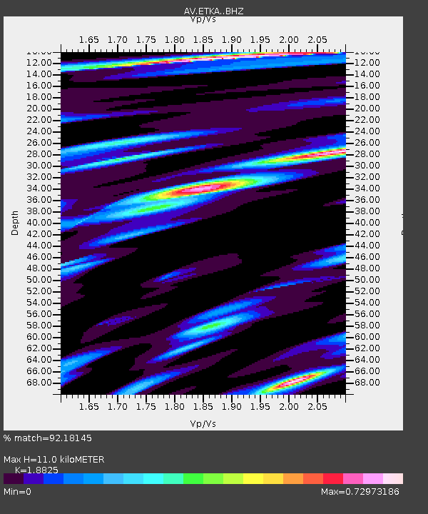
| Estimated Moho Depth: |
11.0 km |
| Estimated Crust Vp/Vs: |
1.88 |
| Assumed Crust Vp: |
5.88 km/s |
| Estimated Crust Vs: |
3.124 km/s |
| Estimated Crust Poisson's Ratio: |
0.30 |
|
| Radial Match: |
92.18145 % |
| Radial Bump: |
312 |
| Transverse Match: |
77.95836 % |
| Transverse Bump: |
390 |
| SOD ConfigId: |
19053131 |
| Insert Time: |
2019-08-10 18:34:18.663 +0000 |
| GWidth: |
2.5 |
| Max Bumps: |
400 |
| Tol: |
0.001 |
|

Signal To Noise
| Channel | StoN | STA | LTA |
| AV:ETKA: :BHZ:20190727T18:37:22.399986Z | 40.70083 | 4.044368E-6 | 9.9368194E-8 |
| AV:ETKA: :BHN:20190727T18:37:22.399986Z | 15.122595 | 1.4900764E-6 | 9.853312E-8 |
| AV:ETKA: :BHE:20190727T18:37:22.399986Z | 31.569494 | 3.067985E-6 | 9.718195E-8 |
| Arrivals |
| Ps | 1.7 SECOND |
| PpPs | 5.1 SECOND |
| PsPs/PpSs | 6.9 SECOND |


