You are here: Home > Network List > AV - Alaska Volcano Observatory Stations List
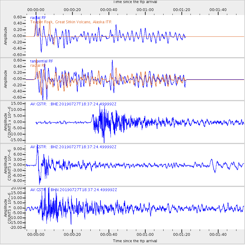
> Station GSTR Teapot Rock, Great Sitkin Volcano, Alaska > Earthquake Result Viewer
GSTR Teapot Rock, Great Sitkin Volcano, Alaska - Earthquake Result Viewer
| Earthquake location: |
Near S. Coast Of Honshu, Japan |
| Earthquake latitude/longitude: |
33.1/137.3 |
| Earthquake time(UTC): |
2019/07/27 (208) 18:31:07 GMT |
| Earthquake Depth: |
367 km |
| Earthquake Magnitude: |
6.3 Mww |
| Earthquake Catalog/Contributor: |
NEIC PDE/us |
|
| Network: |
AV Alaska Volcano Observatory |
| Station: |
GSTR Teapot Rock, Great Sitkin Volcano, Alaska |
| Lat/Lon: |
52.09 N/176.06 W |
| Elevation: |
536 m |
|
| Distance: |
38.4 deg |
| Az: |
46.222 deg |
| Baz: |
259.065 deg |
| Ray Param: |
0.07402119 |
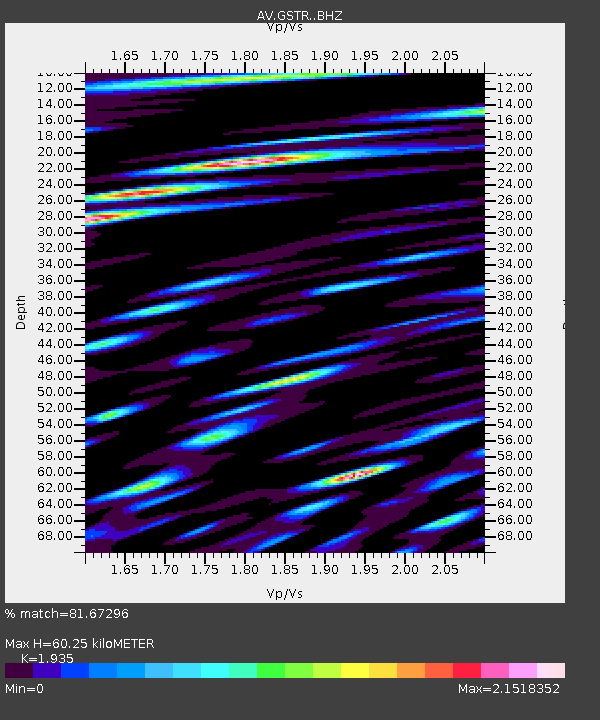
| Estimated Moho Depth: |
60.25 km |
| Estimated Crust Vp/Vs: |
1.93 |
| Assumed Crust Vp: |
3.912 km/s |
| Estimated Crust Vs: |
2.022 km/s |
| Estimated Crust Poisson's Ratio: |
0.32 |
|
| Radial Match: |
81.67296 % |
| Radial Bump: |
400 |
| Transverse Match: |
64.34556 % |
| Transverse Bump: |
400 |
| SOD ConfigId: |
19053131 |
| Insert Time: |
2019-08-10 18:34:22.088 +0000 |
| GWidth: |
2.5 |
| Max Bumps: |
400 |
| Tol: |
0.001 |
|
Signal To Noise
| Channel | StoN | STA | LTA |
| AV:GSTR: :BHZ:20190727T18:37:24.499992Z | 16.213768 | 5.159466E-6 | 3.1821514E-7 |
| AV:GSTR: :BHN:20190727T18:37:24.499992Z | 4.644854 | 4.5269508E-6 | 9.746163E-7 |
| AV:GSTR: :BHE:20190727T18:37:24.499992Z | 8.137166 | 3.8829935E-6 | 4.771923E-7 |
| Arrivals |
| Ps | 15 SECOND |
| PpPs | 44 SECOND |
| PsPs/PpSs | 59 SECOND |


