You are here: Home > Network List > TA - USArray Transportable Network (new EarthScope stations) Stations List
> Station F05A White Salmon, WA, USA > Earthquake Result Viewer
F05A White Salmon, WA, USA - Earthquake Result Viewer
| Earthquake location: |
Kuril Islands |
| Earthquake latitude/longitude: |
46.5/153.2 |
| Earthquake time(UTC): |
2006/10/01 (274) 09:06:02 GMT |
| Earthquake Depth: |
19 km |
| Earthquake Magnitude: |
6.1 MB, 6.4 MS, 6.6 MW, 6.5 MW |
| Earthquake Catalog/Contributor: |
WHDF/NEIC |
|
| Network: |
TA USArray Transportable Network (new EarthScope stations) |
| Station: |
F05A White Salmon, WA, USA |
| Lat/Lon: |
45.88 N/121.46 W |
| Elevation: |
455 m |
|
| Distance: |
56.2 deg |
| Az: |
56.934 deg |
| Baz: |
303.982 deg |
| Ray Param: |
0.06429409 |
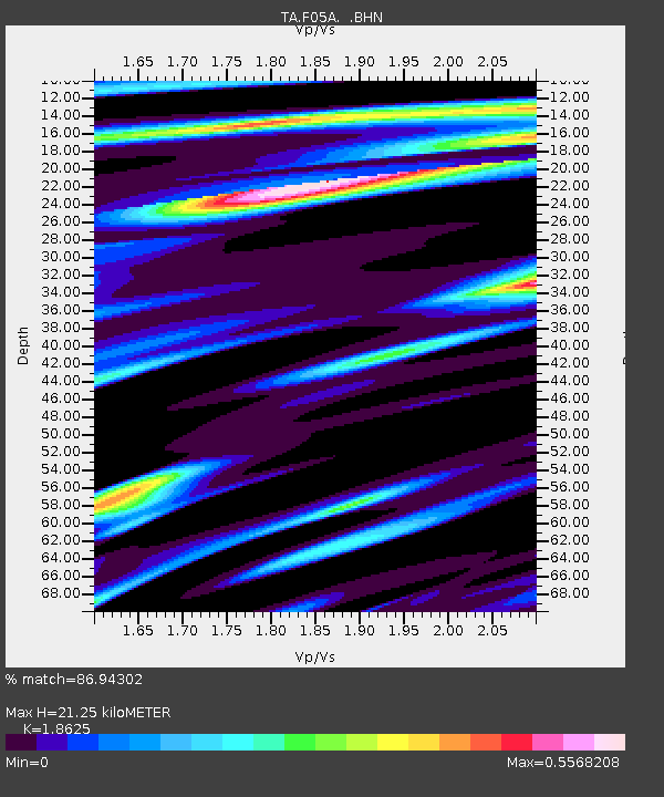
| Estimated Moho Depth: |
21.25 km |
| Estimated Crust Vp/Vs: |
1.86 |
| Assumed Crust Vp: |
6.597 km/s |
| Estimated Crust Vs: |
3.542 km/s |
| Estimated Crust Poisson's Ratio: |
0.30 |
|
| Radial Match: |
86.94302 % |
| Radial Bump: |
400 |
| Transverse Match: |
83.69737 % |
| Transverse Bump: |
400 |
| SOD ConfigId: |
2665 |
| Insert Time: |
2010-03-07 02:17:33.217 +0000 |
| GWidth: |
2.5 |
| Max Bumps: |
400 |
| Tol: |
0.001 |
|
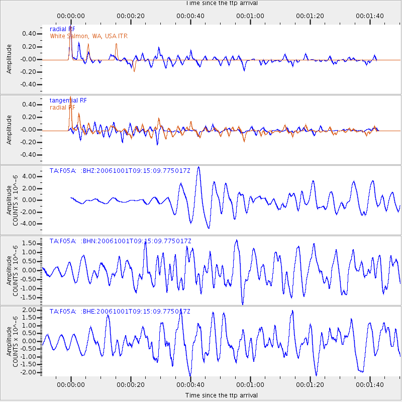
Signal To Noise
| Channel | StoN | STA | LTA |
| TA:F05A: :BHN:20061001T09:15:09.775017Z | 2.5837994 | 5.3776074E-7 | 2.081279E-7 |
| TA:F05A: :BHE:20061001T09:15:09.775017Z | 1.726747 | 5.160351E-7 | 2.988481E-7 |
| TA:F05A: :BHZ:20061001T09:15:09.775017Z | 3.5987313 | 9.406879E-7 | 2.6139435E-7 |
| Arrivals |
| Ps | 2.9 SECOND |
| PpPs | 8.8 SECOND |
| PsPs/PpSs | 12 SECOND |


