You are here: Home > Network List > IW - Intermountain West Stations List
> Station MOOW Moose Ponds, Wyoming, USA > Earthquake Result Viewer
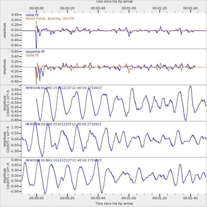
MOOW Moose Ponds, Wyoming, USA - Earthquake Result Viewer
*The percent match for this event was below the threshold and hence no stack was calculated.
| Earthquake location: |
Solomon Islands |
| Earthquake latitude/longitude: |
-10.2/160.9 |
| Earthquake time(UTC): |
2016/12/20 (355) 12:33:15 GMT |
| Earthquake Depth: |
12 km |
| Earthquake Magnitude: |
5.9 mb |
| Earthquake Catalog/Contributor: |
NEIC PDE/us |
|
| Network: |
IW Intermountain West |
| Station: |
MOOW Moose Ponds, Wyoming, USA |
| Lat/Lon: |
43.75 N/110.74 W |
| Elevation: |
2128 m |
|
| Distance: |
95.7 deg |
| Az: |
46.721 deg |
| Baz: |
261.523 deg |
| Ray Param: |
$rayparam |
*The percent match for this event was below the threshold and hence was not used in the summary stack. |
|
| Radial Match: |
69.602356 % |
| Radial Bump: |
400 |
| Transverse Match: |
81.26846 % |
| Transverse Bump: |
400 |
| SOD ConfigId: |
1894071 |
| Insert Time: |
2017-01-03 12:34:48.233 +0000 |
| GWidth: |
2.5 |
| Max Bumps: |
400 |
| Tol: |
0.001 |
|
Signal To Noise
| Channel | StoN | STA | LTA |
| IW:MOOW:00:BHZ:20161220T12:46:09.373992Z | 2.5304623 | 1.0478179E-6 | 4.1408163E-7 |
| IW:MOOW:00:BH1:20161220T12:46:09.373992Z | 1.6289101 | 5.7467895E-7 | 3.527997E-7 |
| IW:MOOW:00:BH2:20161220T12:46:09.373992Z | 1.1615173 | 5.543919E-7 | 4.772997E-7 |
| Arrivals |
| Ps | |
| PpPs | |
| PsPs/PpSs | |


