You are here: Home > Network List > CN - Canadian National Seismograph Network Stations List
> Station PTRF Port Renfrew PTRF, BC, CA > Earthquake Result Viewer
PTRF Port Renfrew PTRF, BC, CA - Earthquake Result Viewer
| Earthquake location: |
Near S. Coast Of Honshu, Japan |
| Earthquake latitude/longitude: |
33.1/137.3 |
| Earthquake time(UTC): |
2019/07/27 (208) 18:31:07 GMT |
| Earthquake Depth: |
367 km |
| Earthquake Magnitude: |
6.3 Mww |
| Earthquake Catalog/Contributor: |
NEIC PDE/us |
|
| Network: |
CN Canadian National Seismograph Network |
| Station: |
PTRF Port Renfrew PTRF, BC, CA |
| Lat/Lon: |
48.54 N/124.41 W |
| Elevation: |
164 m |
|
| Distance: |
70.9 deg |
| Az: |
44.09 deg |
| Baz: |
298.55 deg |
| Ray Param: |
0.05353606 |
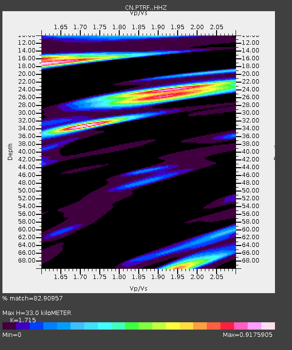
| Estimated Moho Depth: |
33.0 km |
| Estimated Crust Vp/Vs: |
1.72 |
| Assumed Crust Vp: |
6.391 km/s |
| Estimated Crust Vs: |
3.726 km/s |
| Estimated Crust Poisson's Ratio: |
0.24 |
|
| Radial Match: |
82.90957 % |
| Radial Bump: |
360 |
| Transverse Match: |
78.988754 % |
| Transverse Bump: |
400 |
| SOD ConfigId: |
19053131 |
| Insert Time: |
2019-08-10 18:36:47.916 +0000 |
| GWidth: |
2.5 |
| Max Bumps: |
400 |
| Tol: |
0.001 |
|

Signal To Noise
| Channel | StoN | STA | LTA |
| CN:PTRF: :HHZ:20190727T18:41:15.07003Z | 23.428915 | 3.495549E-6 | 1.4919807E-7 |
| CN:PTRF: :HHN:20190727T18:41:15.07003Z | 6.5566087 | 7.5892643E-7 | 1.1574985E-7 |
| CN:PTRF: :HHE:20190727T18:41:15.07003Z | 8.879065 | 1.185443E-6 | 1.335099E-7 |
| Arrivals |
| Ps | 3.8 SECOND |
| PpPs | 14 SECOND |
| PsPs/PpSs | 17 SECOND |


