You are here: Home > Network List > US - United States National Seismic Network Stations List
> Station LKWY Lake (Yellowstone--Lake), Wyoming, USA > Earthquake Result Viewer
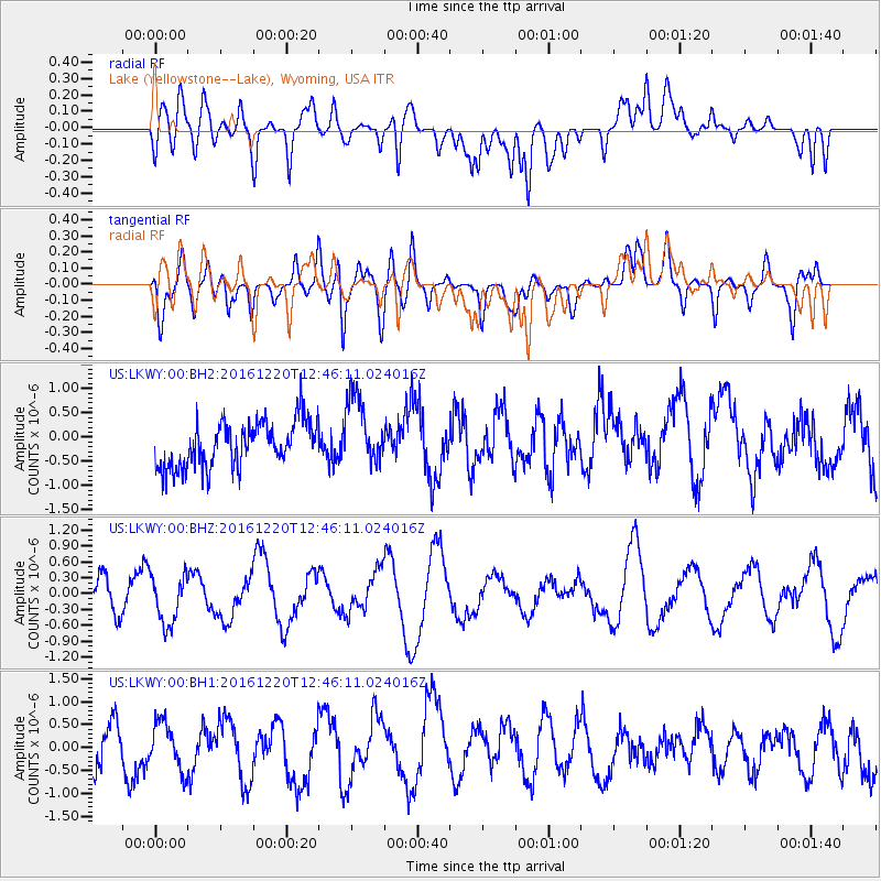
LKWY Lake (Yellowstone--Lake), Wyoming, USA - Earthquake Result Viewer
*The percent match for this event was below the threshold and hence no stack was calculated.
| Earthquake location: |
Solomon Islands |
| Earthquake latitude/longitude: |
-10.2/160.9 |
| Earthquake time(UTC): |
2016/12/20 (355) 12:33:15 GMT |
| Earthquake Depth: |
12 km |
| Earthquake Magnitude: |
5.9 mb |
| Earthquake Catalog/Contributor: |
NEIC PDE/us |
|
| Network: |
US United States National Seismic Network |
| Station: |
LKWY Lake (Yellowstone--Lake), Wyoming, USA |
| Lat/Lon: |
44.57 N/110.40 W |
| Elevation: |
2424 m |
|
| Distance: |
96.1 deg |
| Az: |
45.945 deg |
| Baz: |
261.843 deg |
| Ray Param: |
$rayparam |
*The percent match for this event was below the threshold and hence was not used in the summary stack. |
|
| Radial Match: |
43.765343 % |
| Radial Bump: |
400 |
| Transverse Match: |
36.633015 % |
| Transverse Bump: |
400 |
| SOD ConfigId: |
1894071 |
| Insert Time: |
2017-01-03 12:35:07.728 +0000 |
| GWidth: |
2.5 |
| Max Bumps: |
400 |
| Tol: |
0.001 |
|
Signal To Noise
| Channel | StoN | STA | LTA |
| US:LKWY:00:BHZ:20161220T12:46:11.024016Z | 2.1533294 | 4.6517852E-7 | 2.1602756E-7 |
| US:LKWY:00:BH1:20161220T12:46:11.024016Z | 0.8875878 | 5.20021E-7 | 5.8588114E-7 |
| US:LKWY:00:BH2:20161220T12:46:11.024016Z | 1.550014 | 7.345491E-7 | 4.7389838E-7 |
| Arrivals |
| Ps | |
| PpPs | |
| PsPs/PpSs | |


