You are here: Home > Network List > UU - University of Utah Regional Network Stations List
> Station FOR4 Blundell West, UT, USA > Earthquake Result Viewer
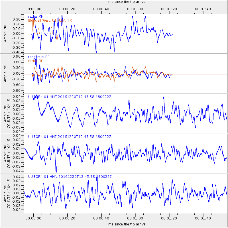
FOR4 Blundell West, UT, USA - Earthquake Result Viewer
*The percent match for this event was below the threshold and hence no stack was calculated.
| Earthquake location: |
Solomon Islands |
| Earthquake latitude/longitude: |
-10.2/160.9 |
| Earthquake time(UTC): |
2016/12/20 (355) 12:33:15 GMT |
| Earthquake Depth: |
12 km |
| Earthquake Magnitude: |
5.9 mb |
| Earthquake Catalog/Contributor: |
NEIC PDE/us |
|
| Network: |
UU University of Utah Regional Network |
| Station: |
FOR4 Blundell West, UT, USA |
| Lat/Lon: |
38.50 N/112.90 W |
| Elevation: |
1657 m |
|
| Distance: |
93.3 deg |
| Az: |
51.646 deg |
| Baz: |
259.725 deg |
| Ray Param: |
$rayparam |
*The percent match for this event was below the threshold and hence was not used in the summary stack. |
|
| Radial Match: |
44.92377 % |
| Radial Bump: |
400 |
| Transverse Match: |
65.161606 % |
| Transverse Bump: |
400 |
| SOD ConfigId: |
1894071 |
| Insert Time: |
2017-01-03 12:35:42.803 +0000 |
| GWidth: |
2.5 |
| Max Bumps: |
400 |
| Tol: |
0.001 |
|
Signal To Noise
| Channel | StoN | STA | LTA |
| UU:FOR4:01:HHZ:20161220T12:45:58.180022Z | 1.3995678 | 1.30598234E-8 | 9.331326E-9 |
| UU:FOR4:01:HHN:20161220T12:45:58.180022Z | 1.5075587 | 1.0173356E-8 | 6.748232E-9 |
| UU:FOR4:01:HHE:20161220T12:45:58.180022Z | 0.8757024 | 1.5265805E-8 | 1.743264E-8 |
| Arrivals |
| Ps | |
| PpPs | |
| PsPs/PpSs | |


