You are here: Home > Network List > N4 - Central and EAstern US Network Stations List
> Station E38A The Farm, Brule, WI, USA > Earthquake Result Viewer
E38A The Farm, Brule, WI, USA - Earthquake Result Viewer
| Earthquake location: |
Near S. Coast Of Honshu, Japan |
| Earthquake latitude/longitude: |
33.1/137.3 |
| Earthquake time(UTC): |
2019/07/27 (208) 18:31:07 GMT |
| Earthquake Depth: |
367 km |
| Earthquake Magnitude: |
6.3 Mww |
| Earthquake Catalog/Contributor: |
NEIC PDE/us |
|
| Network: |
N4 Central and EAstern US Network |
| Station: |
E38A The Farm, Brule, WI, USA |
| Lat/Lon: |
46.61 N/91.55 W |
| Elevation: |
341 m |
|
| Distance: |
89.2 deg |
| Az: |
31.294 deg |
| Baz: |
320.797 deg |
| Ray Param: |
0.041671924 |
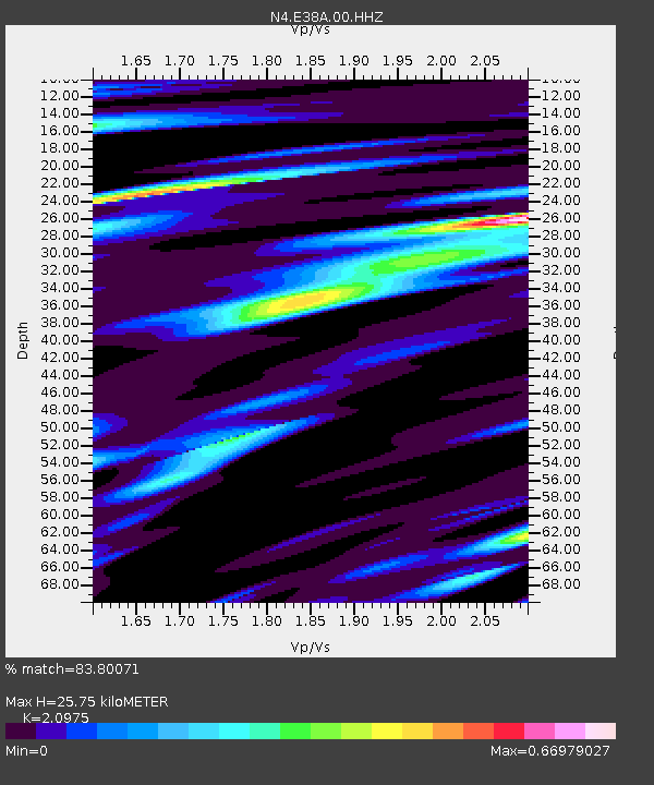
| Estimated Moho Depth: |
25.75 km |
| Estimated Crust Vp/Vs: |
2.10 |
| Assumed Crust Vp: |
6.467 km/s |
| Estimated Crust Vs: |
3.083 km/s |
| Estimated Crust Poisson's Ratio: |
0.35 |
|
| Radial Match: |
83.80071 % |
| Radial Bump: |
400 |
| Transverse Match: |
76.52133 % |
| Transverse Bump: |
400 |
| SOD ConfigId: |
19053131 |
| Insert Time: |
2019-08-10 18:38:57.209 +0000 |
| GWidth: |
2.5 |
| Max Bumps: |
400 |
| Tol: |
0.001 |
|

Signal To Noise
| Channel | StoN | STA | LTA |
| N4:E38A:00:HHZ:20190727T18:42:51.250023Z | 24.915056 | 2.061299E-6 | 8.273307E-8 |
| N4:E38A:00:HH1:20190727T18:42:51.250023Z | 6.6941495 | 7.2898405E-7 | 1.0889868E-7 |
| N4:E38A:00:HH2:20190727T18:42:51.250023Z | 4.79033 | 4.9698633E-7 | 1.0374782E-7 |
| Arrivals |
| Ps | 4.4 SECOND |
| PpPs | 12 SECOND |
| PsPs/PpSs | 17 SECOND |


