You are here: Home > Network List > TA - USArray Transportable Network (new EarthScope stations) Stations List
> Station A19K Wainwright, AK, USA > Earthquake Result Viewer
A19K Wainwright, AK, USA - Earthquake Result Viewer
| Earthquake location: |
Near S. Coast Of Honshu, Japan |
| Earthquake latitude/longitude: |
33.1/137.3 |
| Earthquake time(UTC): |
2019/07/27 (208) 18:31:07 GMT |
| Earthquake Depth: |
367 km |
| Earthquake Magnitude: |
6.3 Mww |
| Earthquake Catalog/Contributor: |
NEIC PDE/us |
|
| Network: |
TA USArray Transportable Network (new EarthScope stations) |
| Station: |
A19K Wainwright, AK, USA |
| Lat/Lon: |
70.20 N/161.07 W |
| Elevation: |
24 m |
|
| Distance: |
49.6 deg |
| Az: |
23.16 deg |
| Baz: |
255.584 deg |
| Ray Param: |
0.06708472 |
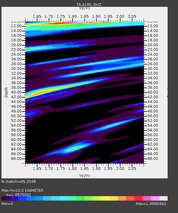
| Estimated Moho Depth: |
10.0 km |
| Estimated Crust Vp/Vs: |
1.86 |
| Assumed Crust Vp: |
5.989 km/s |
| Estimated Crust Vs: |
3.224 km/s |
| Estimated Crust Poisson's Ratio: |
0.30 |
|
| Radial Match: |
85.2049 % |
| Radial Bump: |
388 |
| Transverse Match: |
84.06931 % |
| Transverse Bump: |
363 |
| SOD ConfigId: |
19053131 |
| Insert Time: |
2019-08-10 18:41:30.024 +0000 |
| GWidth: |
2.5 |
| Max Bumps: |
400 |
| Tol: |
0.001 |
|
Signal To Noise
| Channel | StoN | STA | LTA |
| TA:A19K: :BHZ:20190727T18:38:52.649986Z | 16.237343 | 8.734602E-6 | 5.379329E-7 |
| TA:A19K: :BHN:20190727T18:38:52.649986Z | 2.1490984 | 1.0426386E-6 | 4.8515165E-7 |
| TA:A19K: :BHE:20190727T18:38:52.649986Z | 4.11694 | 2.0180262E-6 | 4.901762E-7 |
| Arrivals |
| Ps | 1.5 SECOND |
| PpPs | 4.6 SECOND |
| PsPs/PpSs | 6.1 SECOND |


