You are here: Home > Network List > TA - USArray Transportable Network (new EarthScope stations) Stations List
> Station B18K Kokolik River, AK, USA > Earthquake Result Viewer
B18K Kokolik River, AK, USA - Earthquake Result Viewer
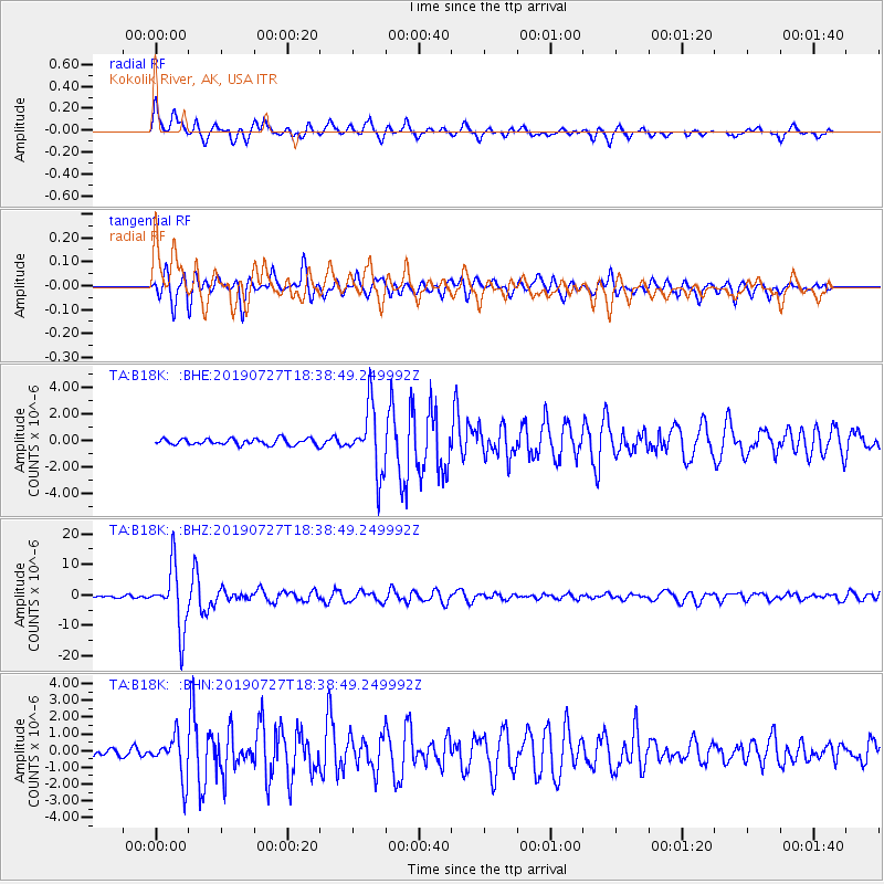
| Earthquake location: |
Near S. Coast Of Honshu, Japan |
| Earthquake latitude/longitude: |
33.1/137.3 |
| Earthquake time(UTC): |
2019/07/27 (208) 18:31:07 GMT |
| Earthquake Depth: |
367 km |
| Earthquake Magnitude: |
6.3 Mww |
| Earthquake Catalog/Contributor: |
NEIC PDE/us |
|
| Network: |
TA USArray Transportable Network (new EarthScope stations) |
| Station: |
B18K Kokolik River, AK, USA |
| Lat/Lon: |
69.36 N/161.80 W |
| Elevation: |
222 m |
|
| Distance: |
49.2 deg |
| Az: |
24.153 deg |
| Baz: |
255.546 deg |
| Ray Param: |
0.06737814 |
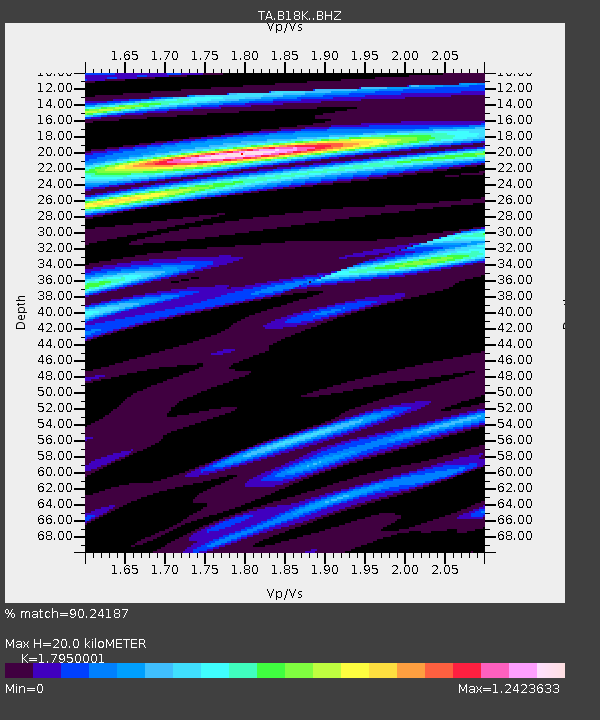
| Estimated Moho Depth: |
20.0 km |
| Estimated Crust Vp/Vs: |
1.80 |
| Assumed Crust Vp: |
5.906 km/s |
| Estimated Crust Vs: |
3.291 km/s |
| Estimated Crust Poisson's Ratio: |
0.27 |
|
| Radial Match: |
90.24187 % |
| Radial Bump: |
383 |
| Transverse Match: |
88.28377 % |
| Transverse Bump: |
400 |
| SOD ConfigId: |
19053131 |
| Insert Time: |
2019-08-10 18:41:30.551 +0000 |
| GWidth: |
2.5 |
| Max Bumps: |
400 |
| Tol: |
0.001 |
|
Signal To Noise
| Channel | StoN | STA | LTA |
| TA:B18K: :BHZ:20190727T18:38:49.249992Z | 33.03788 | 1.0123777E-5 | 3.064294E-7 |
| TA:B18K: :BHN:20190727T18:38:49.249992Z | 6.340974 | 1.244778E-6 | 1.9630707E-7 |
| TA:B18K: :BHE:20190727T18:38:49.249992Z | 10.538612 | 2.4771905E-6 | 2.350585E-7 |
| Arrivals |
| Ps | 2.8 SECOND |
| PpPs | 9.0 SECOND |
| PsPs/PpSs | 12 SECOND |


