You are here: Home > Network List > TA - USArray Transportable Network (new EarthScope stations) Stations List
> Station H19K Roundabout Mountain, AK, USA > Earthquake Result Viewer
H19K Roundabout Mountain, AK, USA - Earthquake Result Viewer
| Earthquake location: |
Near S. Coast Of Honshu, Japan |
| Earthquake latitude/longitude: |
33.1/137.3 |
| Earthquake time(UTC): |
2019/07/27 (208) 18:31:07 GMT |
| Earthquake Depth: |
367 km |
| Earthquake Magnitude: |
6.3 Mww |
| Earthquake Catalog/Contributor: |
NEIC PDE/us |
|
| Network: |
TA USArray Transportable Network (new EarthScope stations) |
| Station: |
H19K Roundabout Mountain, AK, USA |
| Lat/Lon: |
65.53 N/156.45 W |
| Elevation: |
107 m |
|
| Distance: |
50.5 deg |
| Az: |
29.591 deg |
| Baz: |
263.994 deg |
| Ray Param: |
0.066527046 |
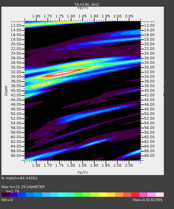
| Estimated Moho Depth: |
32.25 km |
| Estimated Crust Vp/Vs: |
1.76 |
| Assumed Crust Vp: |
6.182 km/s |
| Estimated Crust Vs: |
3.513 km/s |
| Estimated Crust Poisson's Ratio: |
0.26 |
|
| Radial Match: |
94.44853 % |
| Radial Bump: |
282 |
| Transverse Match: |
83.05706 % |
| Transverse Bump: |
369 |
| SOD ConfigId: |
19053131 |
| Insert Time: |
2019-08-10 18:42:05.312 +0000 |
| GWidth: |
2.5 |
| Max Bumps: |
400 |
| Tol: |
0.001 |
|

Signal To Noise
| Channel | StoN | STA | LTA |
| TA:H19K: :BHZ:20190727T18:38:59.274986Z | 106.054405 | 7.0339374E-6 | 6.632386E-8 |
| TA:H19K: :BHN:20190727T18:38:59.274986Z | 9.720891 | 6.6012313E-7 | 6.790768E-8 |
| TA:H19K: :BHE:20190727T18:38:59.274986Z | 67.174286 | 4.109655E-6 | 6.1178994E-8 |
| Arrivals |
| Ps | 4.2 SECOND |
| PpPs | 14 SECOND |
| PsPs/PpSs | 18 SECOND |


