You are here: Home > Network List > TA - USArray Transportable Network (new EarthScope stations) Stations List
> Station I23K Minto, Yukon-Koyukuk, AK, USA > Earthquake Result Viewer
I23K Minto, Yukon-Koyukuk, AK, USA - Earthquake Result Viewer
| Earthquake location: |
Near S. Coast Of Honshu, Japan |
| Earthquake latitude/longitude: |
33.1/137.3 |
| Earthquake time(UTC): |
2019/07/27 (208) 18:31:07 GMT |
| Earthquake Depth: |
367 km |
| Earthquake Magnitude: |
6.3 Mww |
| Earthquake Catalog/Contributor: |
NEIC PDE/us |
|
| Network: |
TA USArray Transportable Network (new EarthScope stations) |
| Station: |
I23K Minto, Yukon-Koyukuk, AK, USA |
| Lat/Lon: |
65.15 N/149.36 W |
| Elevation: |
149 m |
|
| Distance: |
53.5 deg |
| Az: |
30.243 deg |
| Baz: |
270.832 deg |
| Ray Param: |
0.0646482 |
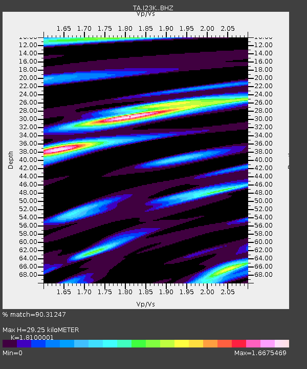
| Estimated Moho Depth: |
29.25 km |
| Estimated Crust Vp/Vs: |
1.81 |
| Assumed Crust Vp: |
6.566 km/s |
| Estimated Crust Vs: |
3.628 km/s |
| Estimated Crust Poisson's Ratio: |
0.28 |
|
| Radial Match: |
90.31247 % |
| Radial Bump: |
357 |
| Transverse Match: |
78.84077 % |
| Transverse Bump: |
400 |
| SOD ConfigId: |
19053131 |
| Insert Time: |
2019-08-10 18:42:13.754 +0000 |
| GWidth: |
2.5 |
| Max Bumps: |
400 |
| Tol: |
0.001 |
|
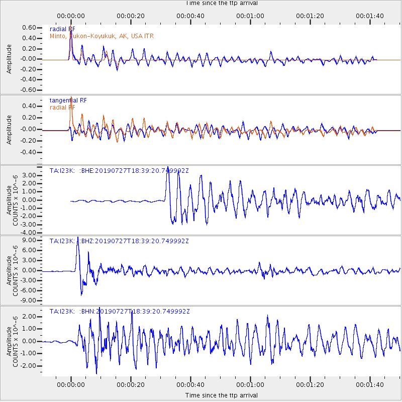
Signal To Noise
| Channel | StoN | STA | LTA |
| TA:I23K: :BHZ:20190727T18:39:20.749992Z | 44.185448 | 4.244754E-6 | 9.6066785E-8 |
| TA:I23K: :BHN:20190727T18:39:20.749992Z | 4.532946 | 4.389953E-7 | 9.684547E-8 |
| TA:I23K: :BHE:20190727T18:39:20.749992Z | 28.274792 | 1.9924341E-6 | 7.04668E-8 |
| Arrivals |
| Ps | 3.8 SECOND |
| PpPs | 12 SECOND |
| PsPs/PpSs | 16 SECOND |


