You are here: Home > Network List > TA - USArray Transportable Network (new EarthScope stations) Stations List
> Station R06C Coleville, CA, USA > Earthquake Result Viewer
R06C Coleville, CA, USA - Earthquake Result Viewer
| Earthquake location: |
South Of Panama |
| Earthquake latitude/longitude: |
6.8/-82.4 |
| Earthquake time(UTC): |
2005/08/27 (239) 18:38:20 GMT |
| Earthquake Depth: |
10 km |
| Earthquake Magnitude: |
5.6 MB, 5.6 MS, 6.2 MW, 6.1 MW |
| Earthquake Catalog/Contributor: |
WHDF/NEIC |
|
| Network: |
TA USArray Transportable Network (new EarthScope stations) |
| Station: |
R06C Coleville, CA, USA |
| Lat/Lon: |
38.52 N/119.45 W |
| Elevation: |
1698 m |
|
| Distance: |
46.0 deg |
| Az: |
318.937 deg |
| Baz: |
123.737 deg |
| Ray Param: |
0.07093545 |
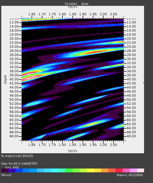
| Estimated Moho Depth: |
39.0 km |
| Estimated Crust Vp/Vs: |
1.64 |
| Assumed Crust Vp: |
6.279 km/s |
| Estimated Crust Vs: |
3.817 km/s |
| Estimated Crust Poisson's Ratio: |
0.21 |
|
| Radial Match: |
82.95425 % |
| Radial Bump: |
400 |
| Transverse Match: |
69.04582 % |
| Transverse Bump: |
400 |
| SOD ConfigId: |
2475 |
| Insert Time: |
2010-03-07 02:21:01.050 +0000 |
| GWidth: |
2.5 |
| Max Bumps: |
400 |
| Tol: |
0.001 |
|

Signal To Noise
| Channel | StoN | STA | LTA |
| TA:R06C: :BHN:20050827T18:46:13.174009Z | 3.3144193 | 2.1120287E-7 | 6.372244E-8 |
| TA:R06C: :BHE:20050827T18:46:13.174009Z | 4.0291 | 3.1957143E-7 | 7.931584E-8 |
| TA:R06C: :BHZ:20050827T18:46:13.174009Z | 10.47336 | 6.614116E-7 | 6.315181E-8 |
| Arrivals |
| Ps | 4.3 SECOND |
| PpPs | 15 SECOND |
| PsPs/PpSs | 20 SECOND |


