You are here: Home > Network List > TA - USArray Transportable Network (new EarthScope stations) Stations List
> Station K15K Wolf Creek Mountain, AK, USA > Earthquake Result Viewer
K15K Wolf Creek Mountain, AK, USA - Earthquake Result Viewer
| Earthquake location: |
Near S. Coast Of Honshu, Japan |
| Earthquake latitude/longitude: |
33.1/137.3 |
| Earthquake time(UTC): |
2019/07/27 (208) 18:31:07 GMT |
| Earthquake Depth: |
367 km |
| Earthquake Magnitude: |
6.3 Mww |
| Earthquake Catalog/Contributor: |
NEIC PDE/us |
|
| Network: |
TA USArray Transportable Network (new EarthScope stations) |
| Station: |
K15K Wolf Creek Mountain, AK, USA |
| Lat/Lon: |
62.29 N/161.53 W |
| Elevation: |
346 m |
|
| Distance: |
47.9 deg |
| Az: |
33.481 deg |
| Baz: |
261.976 deg |
| Ray Param: |
0.06817708 |
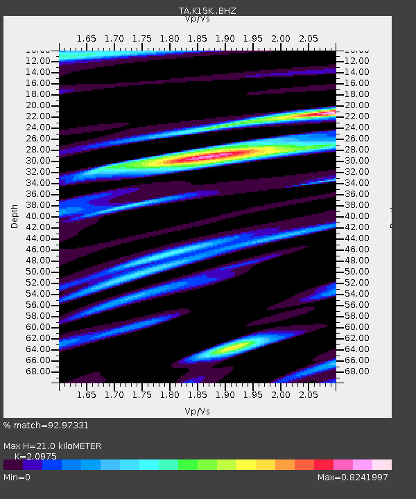
| Estimated Moho Depth: |
21.0 km |
| Estimated Crust Vp/Vs: |
2.10 |
| Assumed Crust Vp: |
6.276 km/s |
| Estimated Crust Vs: |
2.992 km/s |
| Estimated Crust Poisson's Ratio: |
0.35 |
|
| Radial Match: |
92.97331 % |
| Radial Bump: |
362 |
| Transverse Match: |
89.70922 % |
| Transverse Bump: |
368 |
| SOD ConfigId: |
19053131 |
| Insert Time: |
2019-08-10 18:42:21.965 +0000 |
| GWidth: |
2.5 |
| Max Bumps: |
400 |
| Tol: |
0.001 |
|
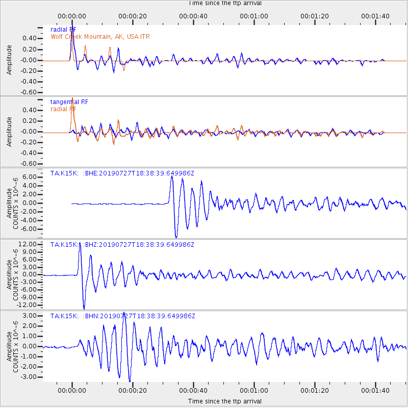
Signal To Noise
| Channel | StoN | STA | LTA |
| TA:K15K: :BHZ:20190727T18:38:39.649986Z | 67.038956 | 6.402363E-6 | 9.550213E-8 |
| TA:K15K: :BHN:20190727T18:38:39.649986Z | 6.380342 | 3.433641E-7 | 5.381594E-8 |
| TA:K15K: :BHE:20190727T18:38:39.649986Z | 85.18538 | 3.827098E-6 | 4.4926704E-8 |
| Arrivals |
| Ps | 3.8 SECOND |
| PpPs | 9.9 SECOND |
| PsPs/PpSs | 14 SECOND |


