You are here: Home > Network List > TA - USArray Transportable Network (new EarthScope stations) Stations List
> Station K17K Iditarod, AK, USA > Earthquake Result Viewer
K17K Iditarod, AK, USA - Earthquake Result Viewer
| Earthquake location: |
Near S. Coast Of Honshu, Japan |
| Earthquake latitude/longitude: |
33.1/137.3 |
| Earthquake time(UTC): |
2019/07/27 (208) 18:31:07 GMT |
| Earthquake Depth: |
367 km |
| Earthquake Magnitude: |
6.3 Mww |
| Earthquake Catalog/Contributor: |
NEIC PDE/us |
|
| Network: |
TA USArray Transportable Network (new EarthScope stations) |
| Station: |
K17K Iditarod, AK, USA |
| Lat/Lon: |
62.72 N/158.30 W |
| Elevation: |
339 m |
|
| Distance: |
49.4 deg |
| Az: |
33.153 deg |
| Baz: |
264.62 deg |
| Ray Param: |
0.06721118 |
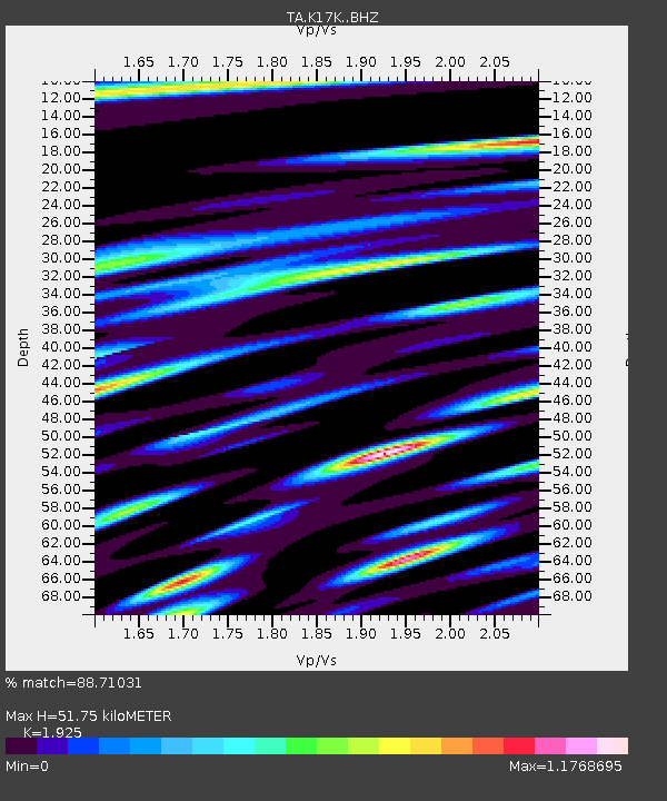
| Estimated Moho Depth: |
51.75 km |
| Estimated Crust Vp/Vs: |
1.92 |
| Assumed Crust Vp: |
6.276 km/s |
| Estimated Crust Vs: |
3.26 km/s |
| Estimated Crust Poisson's Ratio: |
0.32 |
|
| Radial Match: |
88.71031 % |
| Radial Bump: |
400 |
| Transverse Match: |
79.9951 % |
| Transverse Bump: |
400 |
| SOD ConfigId: |
19053131 |
| Insert Time: |
2019-08-10 18:42:23.231 +0000 |
| GWidth: |
2.5 |
| Max Bumps: |
400 |
| Tol: |
0.001 |
|

Signal To Noise
| Channel | StoN | STA | LTA |
| TA:K17K: :BHZ:20190727T18:38:51.200005Z | 73.74364 | 6.228185E-6 | 8.445726E-8 |
| TA:K17K: :BHN:20190727T18:38:51.200005Z | 6.079299 | 5.612576E-7 | 9.232274E-8 |
| TA:K17K: :BHE:20190727T18:38:51.200005Z | 47.415215 | 3.507469E-6 | 7.3973496E-8 |
| Arrivals |
| Ps | 8.0 SECOND |
| PpPs | 23 SECOND |
| PsPs/PpSs | 31 SECOND |


