You are here: Home > Network List > TA - USArray Transportable Network (new EarthScope stations) Stations List
> Station N15K Kwethluk River, AK, USA > Earthquake Result Viewer
N15K Kwethluk River, AK, USA - Earthquake Result Viewer
| Earthquake location: |
Near S. Coast Of Honshu, Japan |
| Earthquake latitude/longitude: |
33.1/137.3 |
| Earthquake time(UTC): |
2019/07/27 (208) 18:31:07 GMT |
| Earthquake Depth: |
367 km |
| Earthquake Magnitude: |
6.3 Mww |
| Earthquake Catalog/Contributor: |
NEIC PDE/us |
|
| Network: |
TA USArray Transportable Network (new EarthScope stations) |
| Station: |
N15K Kwethluk River, AK, USA |
| Lat/Lon: |
60.17 N/160.09 W |
| Elevation: |
449 m |
|
| Distance: |
48.4 deg |
| Az: |
36.431 deg |
| Baz: |
265.204 deg |
| Ray Param: |
0.06788185 |
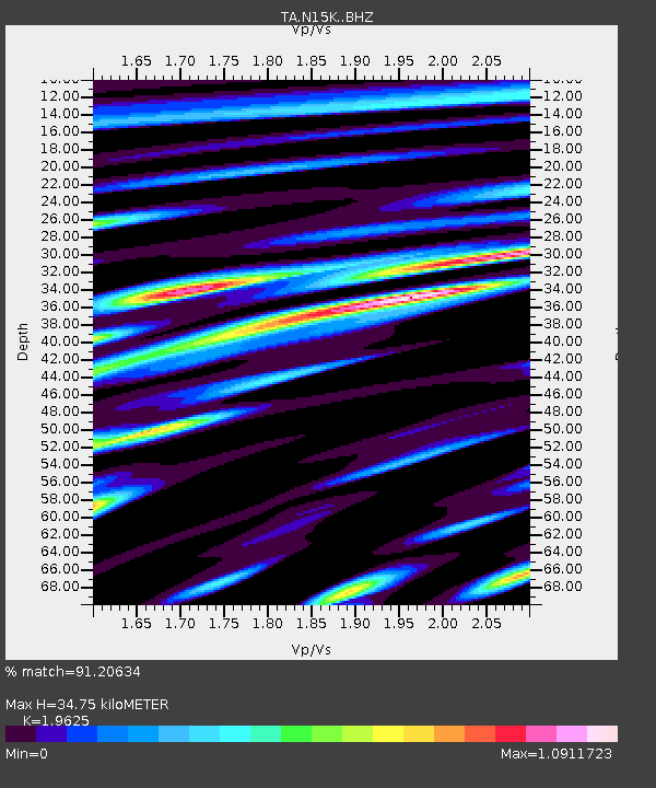
| Estimated Moho Depth: |
34.75 km |
| Estimated Crust Vp/Vs: |
1.96 |
| Assumed Crust Vp: |
6.182 km/s |
| Estimated Crust Vs: |
3.15 km/s |
| Estimated Crust Poisson's Ratio: |
0.32 |
|
| Radial Match: |
91.20634 % |
| Radial Bump: |
400 |
| Transverse Match: |
83.851944 % |
| Transverse Bump: |
400 |
| SOD ConfigId: |
19053131 |
| Insert Time: |
2019-08-10 18:42:41.611 +0000 |
| GWidth: |
2.5 |
| Max Bumps: |
400 |
| Tol: |
0.001 |
|

Signal To Noise
| Channel | StoN | STA | LTA |
| TA:N15K: :BHZ:20190727T18:38:43.075005Z | 51.645275 | 4.796192E-6 | 9.286797E-8 |
| TA:N15K: :BHN:20190727T18:38:43.075005Z | 6.043936 | 4.6371272E-7 | 7.672363E-8 |
| TA:N15K: :BHE:20190727T18:38:43.075005Z | 23.406569 | 2.3444522E-6 | 1.0016216E-7 |
| Arrivals |
| Ps | 5.7 SECOND |
| PpPs | 16 SECOND |
| PsPs/PpSs | 22 SECOND |


