You are here: Home > Network List > TA - USArray Transportable Network (new EarthScope stations) Stations List
> Station T35M Bob Quinn, BC, CAN > Earthquake Result Viewer
T35M Bob Quinn, BC, CAN - Earthquake Result Viewer
| Earthquake location: |
Near S. Coast Of Honshu, Japan |
| Earthquake latitude/longitude: |
33.1/137.3 |
| Earthquake time(UTC): |
2019/07/27 (208) 18:31:07 GMT |
| Earthquake Depth: |
367 km |
| Earthquake Magnitude: |
6.3 Mww |
| Earthquake Catalog/Contributor: |
NEIC PDE/us |
|
| Network: |
TA USArray Transportable Network (new EarthScope stations) |
| Station: |
T35M Bob Quinn, BC, CAN |
| Lat/Lon: |
56.98 N/130.25 W |
| Elevation: |
609 m |
|
| Distance: |
64.2 deg |
| Az: |
37.431 deg |
| Baz: |
291.351 deg |
| Ray Param: |
0.0578899 |
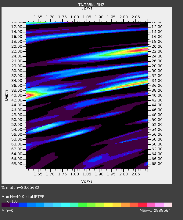
| Estimated Moho Depth: |
40.0 km |
| Estimated Crust Vp/Vs: |
1.60 |
| Assumed Crust Vp: |
6.597 km/s |
| Estimated Crust Vs: |
4.123 km/s |
| Estimated Crust Poisson's Ratio: |
0.18 |
|
| Radial Match: |
86.65632 % |
| Radial Bump: |
400 |
| Transverse Match: |
79.40668 % |
| Transverse Bump: |
400 |
| SOD ConfigId: |
19053131 |
| Insert Time: |
2019-08-10 18:43:07.895 +0000 |
| GWidth: |
2.5 |
| Max Bumps: |
400 |
| Tol: |
0.001 |
|
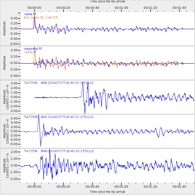
Signal To Noise
| Channel | StoN | STA | LTA |
| TA:T35M: :BHZ:20190727T18:40:33.175011Z | 34.688828 | 3.2892053E-6 | 9.482031E-8 |
| TA:T35M: :BHN:20190727T18:40:33.175011Z | 6.844218 | 5.918715E-7 | 8.6477606E-8 |
| TA:T35M: :BHE:20190727T18:40:33.175011Z | 28.239946 | 1.3232386E-6 | 4.685698E-8 |
| Arrivals |
| Ps | 3.8 SECOND |
| PpPs | 15 SECOND |
| PsPs/PpSs | 19 SECOND |


