You are here: Home > Network List > TA - USArray Transportable Network (new EarthScope stations) Stations List
> Station R06C Coleville, CA, USA > Earthquake Result Viewer
R06C Coleville, CA, USA - Earthquake Result Viewer
| Earthquake location: |
Near West Coast Of Colombia |
| Earthquake latitude/longitude: |
3.0/-78.0 |
| Earthquake time(UTC): |
2007/09/10 (253) 01:49:14 GMT |
| Earthquake Depth: |
31 km |
| Earthquake Magnitude: |
6.1 MB, 6.7 MS, 6.8 MW |
| Earthquake Catalog/Contributor: |
WHDF/NEIC |
|
| Network: |
TA USArray Transportable Network (new EarthScope stations) |
| Station: |
R06C Coleville, CA, USA |
| Lat/Lon: |
38.52 N/119.45 W |
| Elevation: |
1698 m |
|
| Distance: |
51.8 deg |
| Az: |
318.586 deg |
| Baz: |
122.627 deg |
| Ray Param: |
0.06714165 |
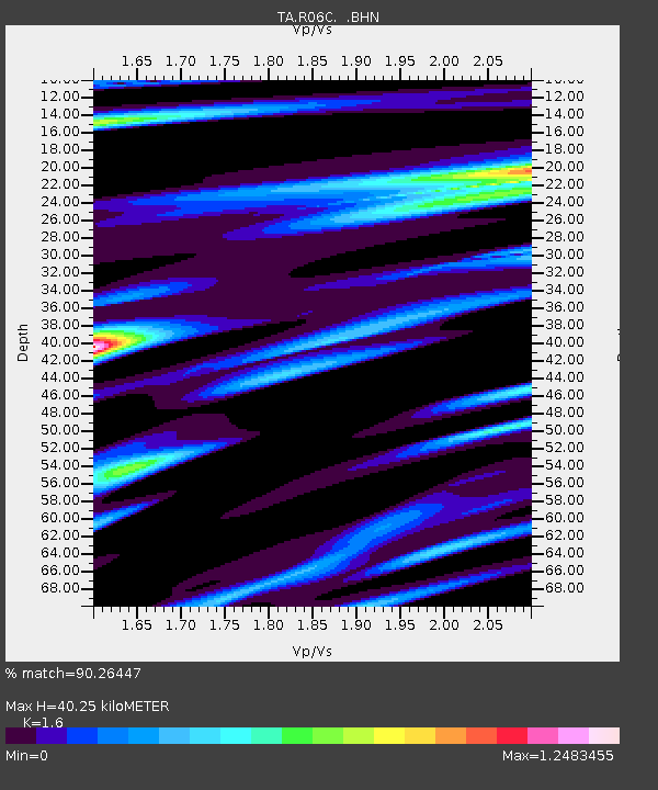
| Estimated Moho Depth: |
40.25 km |
| Estimated Crust Vp/Vs: |
1.60 |
| Assumed Crust Vp: |
6.279 km/s |
| Estimated Crust Vs: |
3.924 km/s |
| Estimated Crust Poisson's Ratio: |
0.18 |
|
| Radial Match: |
90.26447 % |
| Radial Bump: |
400 |
| Transverse Match: |
78.999504 % |
| Transverse Bump: |
400 |
| SOD ConfigId: |
2564 |
| Insert Time: |
2010-03-07 02:21:27.625 +0000 |
| GWidth: |
2.5 |
| Max Bumps: |
400 |
| Tol: |
0.001 |
|

Signal To Noise
| Channel | StoN | STA | LTA |
| TA:R06C: :BHN:20070910T01:57:48.175017Z | 1.1043254 | 2.7395308E-7 | 2.480728E-7 |
| TA:R06C: :BHE:20070910T01:57:48.175017Z | 3.4014893 | 4.4796528E-7 | 1.3169681E-7 |
| TA:R06C: :BHZ:20070910T01:57:48.175017Z | 9.462764 | 1.0299216E-6 | 1.0883941E-7 |
| Arrivals |
| Ps | 4.1 SECOND |
| PpPs | 16 SECOND |
| PsPs/PpSs | 20 SECOND |


