You are here: Home > Network List > ND - New CaleDonia Broadband Seismic Network Stations List
> Station KOUNC Koumac, New Caledonia > Earthquake Result Viewer
KOUNC Koumac, New Caledonia - Earthquake Result Viewer
| Earthquake location: |
Banda Sea |
| Earthquake latitude/longitude: |
-7.5/127.9 |
| Earthquake time(UTC): |
2016/12/21 (356) 00:17:15 GMT |
| Earthquake Depth: |
152 km |
| Earthquake Magnitude: |
6.7 Mww |
| Earthquake Catalog/Contributor: |
NEIC PDE/us |
|
| Network: |
ND New CaleDonia Broadband Seismic Network |
| Station: |
KOUNC Koumac, New Caledonia |
| Lat/Lon: |
20.55 S/164.29 E |
| Elevation: |
88 m |
|
| Distance: |
37.5 deg |
| Az: |
114.032 deg |
| Baz: |
284.91 deg |
| Ray Param: |
0.07553519 |
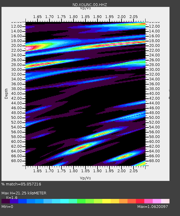
| Estimated Moho Depth: |
21.25 km |
| Estimated Crust Vp/Vs: |
1.60 |
| Assumed Crust Vp: |
5.14 km/s |
| Estimated Crust Vs: |
3.212 km/s |
| Estimated Crust Poisson's Ratio: |
0.18 |
|
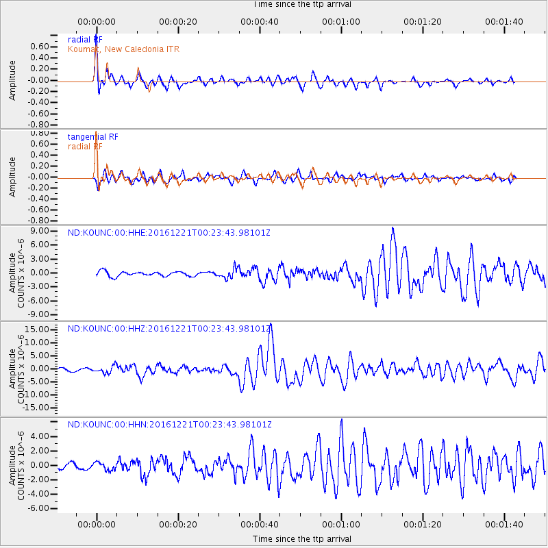
| Radial Match: |
85.857216 % |
| Radial Bump: |
400 |
| Transverse Match: |
77.36575 % |
| Transverse Bump: |
400 |
| SOD ConfigId: |
1894071 |
| Insert Time: |
2017-01-04 00:19:00.184 +0000 |
| GWidth: |
2.5 |
| Max Bumps: |
400 |
| Tol: |
0.001 |
|
Signal To Noise
| Channel | StoN | STA | LTA |
| ND:KOUNC:00:HHZ:20161221T00:23:43.98101Z | 2.5111678 | 1.4296136E-6 | 5.693023E-7 |
| ND:KOUNC:00:HHN:20161221T00:23:43.98101Z | 1.5691255 | 5.334021E-7 | 3.399359E-7 |
| ND:KOUNC:00:HHE:20161221T00:23:43.98101Z | 2.0922809 | 1.0588899E-6 | 5.060936E-7 |
| Arrivals |
| Ps | 2.6 SECOND |
| PpPs | 10 SECOND |
| PsPs/PpSs | 13 SECOND |


