You are here: Home > Network List > TA - USArray Transportable Network (new EarthScope stations) Stations List
> Station R06C Coleville, CA, USA > Earthquake Result Viewer
R06C Coleville, CA, USA - Earthquake Result Viewer
| Earthquake location: |
Tonga Islands Region |
| Earthquake latitude/longitude: |
-23.6/-175.3 |
| Earthquake time(UTC): |
2006/10/08 (281) 13:50:24 GMT |
| Earthquake Depth: |
10 km |
| Earthquake Magnitude: |
5.6 MB, 5.6 MS, 5.8 MW, 5.7 MW |
| Earthquake Catalog/Contributor: |
WHDF/NEIC |
|
| Network: |
TA USArray Transportable Network (new EarthScope stations) |
| Station: |
R06C Coleville, CA, USA |
| Lat/Lon: |
38.52 N/119.45 W |
| Elevation: |
1698 m |
|
| Distance: |
80.9 deg |
| Az: |
41.084 deg |
| Baz: |
230.247 deg |
| Ray Param: |
0.047953818 |
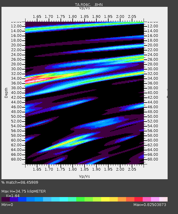
| Estimated Moho Depth: |
34.75 km |
| Estimated Crust Vp/Vs: |
1.64 |
| Assumed Crust Vp: |
6.279 km/s |
| Estimated Crust Vs: |
3.828 km/s |
| Estimated Crust Poisson's Ratio: |
0.20 |
|
| Radial Match: |
86.45989 % |
| Radial Bump: |
400 |
| Transverse Match: |
76.36206 % |
| Transverse Bump: |
400 |
| SOD ConfigId: |
2665 |
| Insert Time: |
2010-03-07 02:22:37.391 +0000 |
| GWidth: |
2.5 |
| Max Bumps: |
400 |
| Tol: |
0.001 |
|

Signal To Noise
| Channel | StoN | STA | LTA |
| TA:R06C: :BHN:20061008T14:02:07.024001Z | 1.7085664 | 1.750959E-7 | 1.0248118E-7 |
| TA:R06C: :BHE:20061008T14:02:07.024001Z | 1.1226625 | 1.3548222E-7 | 1.2067939E-7 |
| TA:R06C: :BHZ:20061008T14:02:07.024001Z | 4.025215 | 3.7567858E-7 | 9.333131E-8 |
| Arrivals |
| Ps | 3.6 SECOND |
| PpPs | 14 SECOND |
| PsPs/PpSs | 18 SECOND |


