You are here: Home > Network List > PF - Volcanologic Network of Piton de Fournaise-OVPF Stations List
> Station CIL Cilaos (Pompiers) > Earthquake Result Viewer
CIL Cilaos (Pompiers) - Earthquake Result Viewer
| Earthquake location: |
Banda Sea |
| Earthquake latitude/longitude: |
-7.5/127.9 |
| Earthquake time(UTC): |
2016/12/21 (356) 00:17:15 GMT |
| Earthquake Depth: |
152 km |
| Earthquake Magnitude: |
6.7 Mww |
| Earthquake Catalog/Contributor: |
NEIC PDE/us |
|
| Network: |
PF Volcanologic Network of Piton de Fournaise-OVPF |
| Station: |
CIL Cilaos (Pompiers) |
| Lat/Lon: |
21.13 S/55.47 E |
| Elevation: |
1223 m |
|
| Distance: |
70.9 deg |
| Az: |
250.292 deg |
| Baz: |
90.835 deg |
| Ray Param: |
0.05425079 |
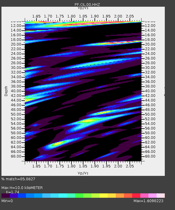
| Estimated Moho Depth: |
10.0 km |
| Estimated Crust Vp/Vs: |
1.74 |
| Assumed Crust Vp: |
4.73 km/s |
| Estimated Crust Vs: |
2.718 km/s |
| Estimated Crust Poisson's Ratio: |
0.25 |
|
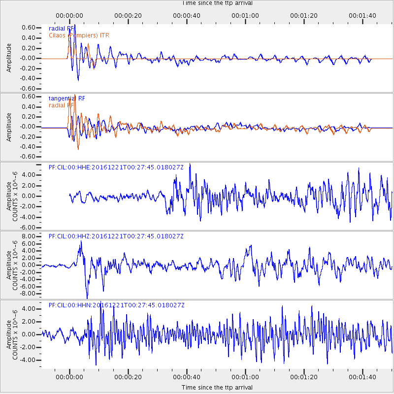
| Radial Match: |
85.8627 % |
| Radial Bump: |
400 |
| Transverse Match: |
75.232544 % |
| Transverse Bump: |
400 |
| SOD ConfigId: |
1894071 |
| Insert Time: |
2017-01-04 00:19:16.495 +0000 |
| GWidth: |
2.5 |
| Max Bumps: |
400 |
| Tol: |
0.001 |
|
Signal To Noise
| Channel | StoN | STA | LTA |
| PF:CIL:00:HHZ:20161221T00:27:45.018027Z | 7.1779213 | 2.560625E-6 | 3.5673628E-7 |
| PF:CIL:00:HHN:20161221T00:27:45.018027Z | 1.7950703 | 6.6497995E-7 | 3.7044785E-7 |
| PF:CIL:00:HHE:20161221T00:27:45.018027Z | 2.9823318 | 1.4412655E-6 | 4.8326797E-7 |
| Arrivals |
| Ps | 1.6 SECOND |
| PpPs | 5.7 SECOND |
| PsPs/PpSs | 7.3 SECOND |


