You are here: Home > Network List > TA - USArray Transportable Network (new EarthScope stations) Stations List
> Station R06C Coleville, CA, USA > Earthquake Result Viewer
R06C Coleville, CA, USA - Earthquake Result Viewer
| Earthquake location: |
South Of Fiji Islands |
| Earthquake latitude/longitude: |
-23.6/-180.0 |
| Earthquake time(UTC): |
2006/02/26 (057) 03:08:27 GMT |
| Earthquake Depth: |
535 km |
| Earthquake Magnitude: |
5.9 MB, 6.4 MW, 6.4 MW |
| Earthquake Catalog/Contributor: |
WHDF/NEIC |
|
| Network: |
TA USArray Transportable Network (new EarthScope stations) |
| Station: |
R06C Coleville, CA, USA |
| Lat/Lon: |
38.52 N/119.45 W |
| Elevation: |
1698 m |
|
| Distance: |
83.9 deg |
| Az: |
43.385 deg |
| Baz: |
233.444 deg |
| Ray Param: |
0.04434526 |
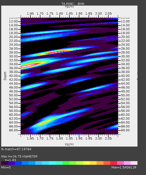
| Estimated Moho Depth: |
34.75 km |
| Estimated Crust Vp/Vs: |
1.63 |
| Assumed Crust Vp: |
6.279 km/s |
| Estimated Crust Vs: |
3.852 km/s |
| Estimated Crust Poisson's Ratio: |
0.20 |
|
| Radial Match: |
87.19764 % |
| Radial Bump: |
400 |
| Transverse Match: |
82.22401 % |
| Transverse Bump: |
400 |
| SOD ConfigId: |
2422 |
| Insert Time: |
2010-03-07 02:23:19.033 +0000 |
| GWidth: |
2.5 |
| Max Bumps: |
400 |
| Tol: |
0.001 |
|

Signal To Noise
| Channel | StoN | STA | LTA |
| TA:R06C: :BHN:20060226T03:19:29.900027Z | 2.61827 | 4.912092E-7 | 1.8760832E-7 |
| TA:R06C: :BHE:20060226T03:19:29.900027Z | 3.6901426 | 8.796811E-7 | 2.3838676E-7 |
| TA:R06C: :BHZ:20060226T03:19:29.900027Z | 21.93653 | 3.438672E-6 | 1.5675552E-7 |
| Arrivals |
| Ps | 3.6 SECOND |
| PpPs | 14 SECOND |
| PsPs/PpSs | 18 SECOND |


