You are here: Home > Network List > TA - USArray Transportable Network (new EarthScope stations) Stations List
> Station R06C Coleville, CA, USA > Earthquake Result Viewer
R06C Coleville, CA, USA - Earthquake Result Viewer
| Earthquake location: |
Fiji Islands Region |
| Earthquake latitude/longitude: |
-18.0/-179.6 |
| Earthquake time(UTC): |
2006/02/24 (055) 14:15:45 GMT |
| Earthquake Depth: |
622 km |
| Earthquake Magnitude: |
5.9 MB, 6.1 MW, 6.0 MW |
| Earthquake Catalog/Contributor: |
WHDF/NEIC |
|
| Network: |
TA USArray Transportable Network (new EarthScope stations) |
| Station: |
R06C Coleville, CA, USA |
| Lat/Lon: |
38.52 N/119.45 W |
| Elevation: |
1698 m |
|
| Distance: |
79.6 deg |
| Az: |
43.766 deg |
| Baz: |
237.06 deg |
| Ray Param: |
0.04692132 |
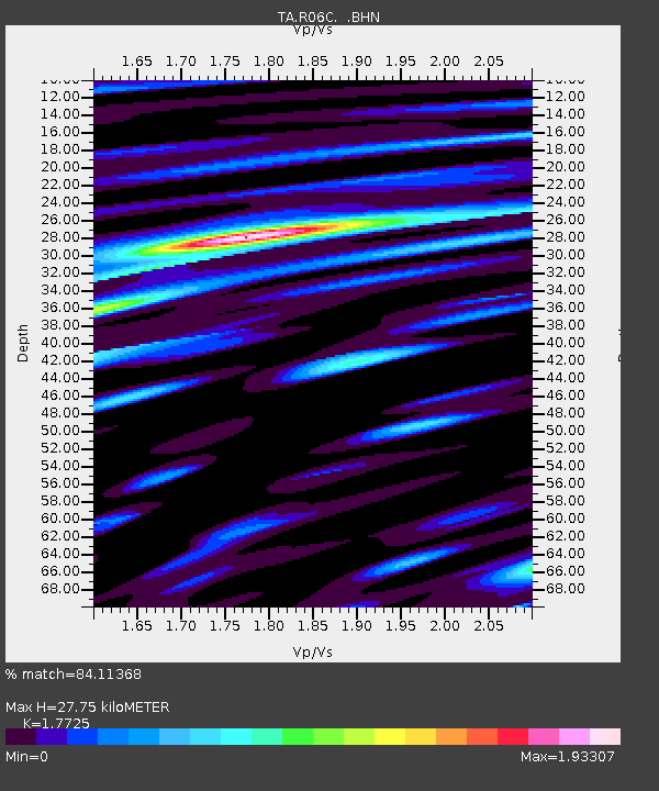
| Estimated Moho Depth: |
27.75 km |
| Estimated Crust Vp/Vs: |
1.77 |
| Assumed Crust Vp: |
6.279 km/s |
| Estimated Crust Vs: |
3.542 km/s |
| Estimated Crust Poisson's Ratio: |
0.27 |
|
| Radial Match: |
84.11368 % |
| Radial Bump: |
400 |
| Transverse Match: |
85.08543 % |
| Transverse Bump: |
400 |
| SOD ConfigId: |
2422 |
| Insert Time: |
2010-03-07 02:23:20.385 +0000 |
| GWidth: |
2.5 |
| Max Bumps: |
400 |
| Tol: |
0.001 |
|

Signal To Noise
| Channel | StoN | STA | LTA |
| TA:R06C: :BHN:20060224T14:26:17.999001Z | 2.462588 | 4.086706E-7 | 1.6595168E-7 |
| TA:R06C: :BHE:20060224T14:26:17.999001Z | 6.3677826 | 8.3527857E-7 | 1.311726E-7 |
| TA:R06C: :BHZ:20060224T14:26:17.999001Z | 11.205463 | 2.6911894E-6 | 2.4016762E-7 |
| Arrivals |
| Ps | 3.5 SECOND |
| PpPs | 12 SECOND |
| PsPs/PpSs | 15 SECOND |


