You are here: Home > Network List > PF - Volcanologic Network of Piton de Fournaise-OVPF Stations List
> Station FRE Station Sismologique des Fonds de la Riviere de l'Est > Earthquake Result Viewer
FRE Station Sismologique des Fonds de la Riviere de l'Est - Earthquake Result Viewer
| Earthquake location: |
Banda Sea |
| Earthquake latitude/longitude: |
-7.5/127.9 |
| Earthquake time(UTC): |
2016/12/21 (356) 00:17:15 GMT |
| Earthquake Depth: |
152 km |
| Earthquake Magnitude: |
6.7 Mww |
| Earthquake Catalog/Contributor: |
NEIC PDE/us |
|
| Network: |
PF Volcanologic Network of Piton de Fournaise-OVPF |
| Station: |
FRE Station Sismologique des Fonds de la Riviere de l'Est |
| Lat/Lon: |
21.20 S/55.70 E |
| Elevation: |
1775 m |
|
| Distance: |
70.7 deg |
| Az: |
250.224 deg |
| Baz: |
90.732 deg |
| Ray Param: |
0.054390956 |
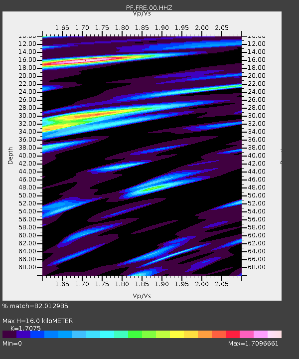
| Estimated Moho Depth: |
16.0 km |
| Estimated Crust Vp/Vs: |
1.71 |
| Assumed Crust Vp: |
4.73 km/s |
| Estimated Crust Vs: |
2.77 km/s |
| Estimated Crust Poisson's Ratio: |
0.24 |
|
| Radial Match: |
82.012985 % |
| Radial Bump: |
400 |
| Transverse Match: |
76.48204 % |
| Transverse Bump: |
400 |
| SOD ConfigId: |
1894071 |
| Insert Time: |
2017-01-04 00:19:39.845 +0000 |
| GWidth: |
2.5 |
| Max Bumps: |
400 |
| Tol: |
0.001 |
|
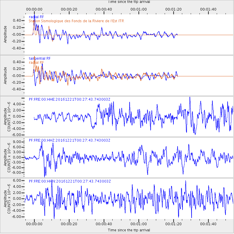
Signal To Noise
| Channel | StoN | STA | LTA |
| PF:FRE:00:HHZ:20161221T00:27:43.743003Z | 4.761461 | 3.3207853E-6 | 6.974299E-7 |
| PF:FRE:00:HHN:20161221T00:27:43.743003Z | 1.3289895 | 1.2393489E-6 | 9.325497E-7 |
| PF:FRE:00:HHE:20161221T00:27:43.743003Z | 2.2721357 | 1.9384615E-6 | 8.531452E-7 |
| Arrivals |
| Ps | 2.4 SECOND |
| PpPs | 9.0 SECOND |
| PsPs/PpSs | 11 SECOND |


