You are here: Home > Network List > TA - USArray Transportable Network (new EarthScope stations) Stations List
> Station U12A Valley of Fire, Overton, NV, USA > Earthquake Result Viewer
U12A Valley of Fire, Overton, NV, USA - Earthquake Result Viewer
| Earthquake location: |
Northern Chile |
| Earthquake latitude/longitude: |
-22.2/-69.9 |
| Earthquake time(UTC): |
2007/11/14 (318) 15:40:50 GMT |
| Earthquake Depth: |
40 km |
| Earthquake Magnitude: |
6.7 MB, 7.4 MS, 7.7 MW, 7.4 ME |
| Earthquake Catalog/Contributor: |
WHDF/NEIC |
|
| Network: |
TA USArray Transportable Network (new EarthScope stations) |
| Station: |
U12A Valley of Fire, Overton, NV, USA |
| Lat/Lon: |
36.43 N/114.54 W |
| Elevation: |
644 m |
|
| Distance: |
72.0 deg |
| Az: |
323.423 deg |
| Baz: |
136.799 deg |
| Ray Param: |
0.053881906 |
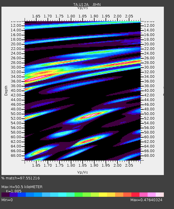
| Estimated Moho Depth: |
50.5 km |
| Estimated Crust Vp/Vs: |
1.88 |
| Assumed Crust Vp: |
6.276 km/s |
| Estimated Crust Vs: |
3.329 km/s |
| Estimated Crust Poisson's Ratio: |
0.30 |
|
| Radial Match: |
97.551216 % |
| Radial Bump: |
400 |
| Transverse Match: |
93.18967 % |
| Transverse Bump: |
400 |
| SOD ConfigId: |
2564 |
| Insert Time: |
2010-03-07 02:23:43.235 +0000 |
| GWidth: |
2.5 |
| Max Bumps: |
400 |
| Tol: |
0.001 |
|
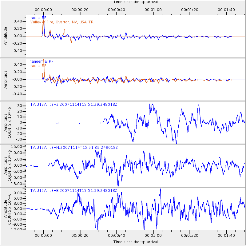
Signal To Noise
| Channel | StoN | STA | LTA |
| TA:U12A: :BHN:20071114T15:51:39.248018Z | 10.032451 | 1.1710896E-6 | 1.1673016E-7 |
| TA:U12A: :BHE:20071114T15:51:39.248018Z | 5.5741 | 1.0554207E-6 | 1.8934371E-7 |
| TA:U12A: :BHZ:20071114T15:51:39.248018Z | 29.579689 | 3.9856436E-6 | 1.3474258E-7 |
| Arrivals |
| Ps | 7.3 SECOND |
| PpPs | 22 SECOND |
| PsPs/PpSs | 30 SECOND |


