You are here: Home > Network List > TA - USArray Transportable Network (new EarthScope stations) Stations List
> Station U12A Valley of Fire, Overton, NV, USA > Earthquake Result Viewer
U12A Valley of Fire, Overton, NV, USA - Earthquake Result Viewer
| Earthquake location: |
South Of Mariana Islands |
| Earthquake latitude/longitude: |
10.5/145.7 |
| Earthquake time(UTC): |
2007/09/30 (273) 02:08:30 GMT |
| Earthquake Depth: |
14 km |
| Earthquake Magnitude: |
6.4 MB, 7.1 MS, 6.9 MW, 6.9 MW |
| Earthquake Catalog/Contributor: |
WHDF/NEIC |
|
| Network: |
TA USArray Transportable Network (new EarthScope stations) |
| Station: |
U12A Valley of Fire, Overton, NV, USA |
| Lat/Lon: |
36.43 N/114.54 W |
| Elevation: |
644 m |
|
| Distance: |
91.6 deg |
| Az: |
52.668 deg |
| Baz: |
284.117 deg |
| Ray Param: |
0.041586183 |
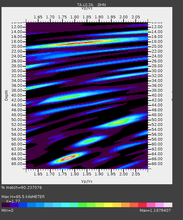
| Estimated Moho Depth: |
65.5 km |
| Estimated Crust Vp/Vs: |
1.77 |
| Assumed Crust Vp: |
6.276 km/s |
| Estimated Crust Vs: |
3.546 km/s |
| Estimated Crust Poisson's Ratio: |
0.27 |
|
| Radial Match: |
90.237076 % |
| Radial Bump: |
400 |
| Transverse Match: |
81.90449 % |
| Transverse Bump: |
400 |
| SOD ConfigId: |
2564 |
| Insert Time: |
2010-03-07 02:23:49.586 +0000 |
| GWidth: |
2.5 |
| Max Bumps: |
400 |
| Tol: |
0.001 |
|
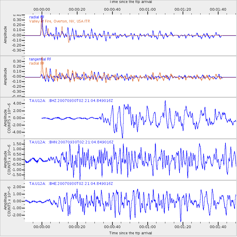
Signal To Noise
| Channel | StoN | STA | LTA |
| TA:U12A: :BHN:20070930T02:21:04.849016Z | 0.70333534 | 1.0671946E-7 | 1.517334E-7 |
| TA:U12A: :BHE:20070930T02:21:04.849016Z | 1.023543 | 1.4077229E-7 | 1.3753431E-7 |
| TA:U12A: :BHZ:20070930T02:21:04.849016Z | 2.7681422 | 4.1112168E-7 | 1.4851898E-7 |
| Arrivals |
| Ps | 8.2 SECOND |
| PpPs | 28 SECOND |
| PsPs/PpSs | 37 SECOND |


