You are here: Home > Network List > TA - USArray Transportable Network (new EarthScope stations) Stations List
> Station U12A Valley of Fire, Overton, NV, USA > Earthquake Result Viewer
U12A Valley of Fire, Overton, NV, USA - Earthquake Result Viewer
| Earthquake location: |
Southeast Of Loyalty Islands |
| Earthquake latitude/longitude: |
-21.1/169.3 |
| Earthquake time(UTC): |
2007/09/27 (270) 19:57:44 GMT |
| Earthquake Depth: |
9.0 km |
| Earthquake Magnitude: |
6.2 MB, 6.3 MS, 6.1 MW, 6.1 MW |
| Earthquake Catalog/Contributor: |
WHDF/NEIC |
|
| Network: |
TA USArray Transportable Network (new EarthScope stations) |
| Station: |
U12A Valley of Fire, Overton, NV, USA |
| Lat/Lon: |
36.43 N/114.54 W |
| Elevation: |
644 m |
|
| Distance: |
91.8 deg |
| Az: |
51.583 deg |
| Baz: |
245.116 deg |
| Ray Param: |
0.04155229 |
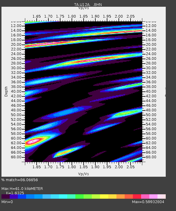
| Estimated Moho Depth: |
61.0 km |
| Estimated Crust Vp/Vs: |
1.63 |
| Assumed Crust Vp: |
6.276 km/s |
| Estimated Crust Vs: |
3.844 km/s |
| Estimated Crust Poisson's Ratio: |
0.20 |
|
| Radial Match: |
86.06656 % |
| Radial Bump: |
400 |
| Transverse Match: |
78.57794 % |
| Transverse Bump: |
400 |
| SOD ConfigId: |
2564 |
| Insert Time: |
2010-03-07 02:23:56.643 +0000 |
| GWidth: |
2.5 |
| Max Bumps: |
400 |
| Tol: |
0.001 |
|
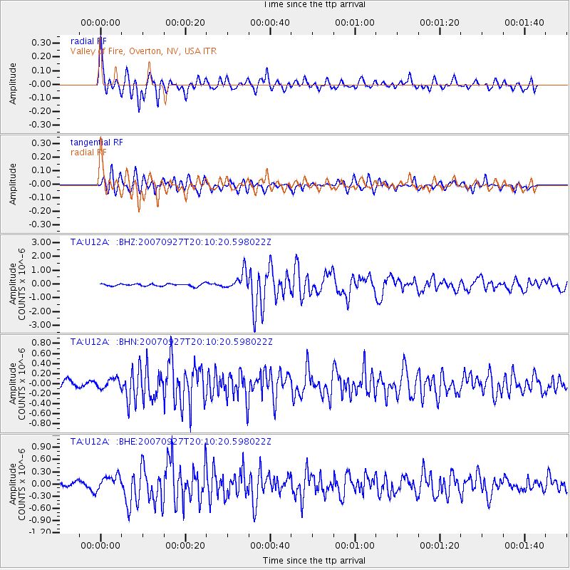
Signal To Noise
| Channel | StoN | STA | LTA |
| TA:U12A: :BHN:20070927T20:10:20.598022Z | 0.886564 | 9.979721E-8 | 1.12566276E-7 |
| TA:U12A: :BHE:20070927T20:10:20.598022Z | 1.6024879 | 1.8157823E-7 | 1.133102E-7 |
| TA:U12A: :BHZ:20070927T20:10:20.598022Z | 7.856654 | 6.627151E-7 | 8.43508E-8 |
| Arrivals |
| Ps | 6.3 SECOND |
| PpPs | 25 SECOND |
| PsPs/PpSs | 31 SECOND |


