You are here: Home > Network List > TA - USArray Transportable Network (new EarthScope stations) Stations List
> Station U12A Valley of Fire, Overton, NV, USA > Earthquake Result Viewer
U12A Valley of Fire, Overton, NV, USA - Earthquake Result Viewer
| Earthquake location: |
Tonga Islands |
| Earthquake latitude/longitude: |
-17.5/-174.3 |
| Earthquake time(UTC): |
2007/08/26 (238) 12:37:31 GMT |
| Earthquake Depth: |
127 km |
| Earthquake Magnitude: |
5.9 MB, 6.1 MW |
| Earthquake Catalog/Contributor: |
WHDF/NEIC |
|
| Network: |
TA USArray Transportable Network (new EarthScope stations) |
| Station: |
U12A Valley of Fire, Overton, NV, USA |
| Lat/Lon: |
36.43 N/114.54 W |
| Elevation: |
644 m |
|
| Distance: |
77.8 deg |
| Az: |
45.481 deg |
| Baz: |
237.557 deg |
| Ray Param: |
0.0497569 |
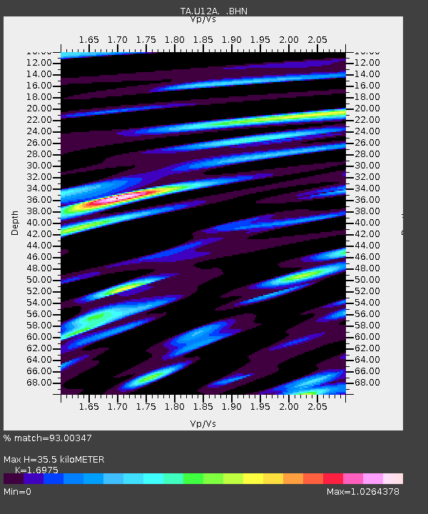
| Estimated Moho Depth: |
35.5 km |
| Estimated Crust Vp/Vs: |
1.70 |
| Assumed Crust Vp: |
6.276 km/s |
| Estimated Crust Vs: |
3.697 km/s |
| Estimated Crust Poisson's Ratio: |
0.23 |
|
| Radial Match: |
93.00347 % |
| Radial Bump: |
400 |
| Transverse Match: |
88.20653 % |
| Transverse Bump: |
400 |
| SOD ConfigId: |
2564 |
| Insert Time: |
2010-03-07 02:24:02.534 +0000 |
| GWidth: |
2.5 |
| Max Bumps: |
400 |
| Tol: |
0.001 |
|
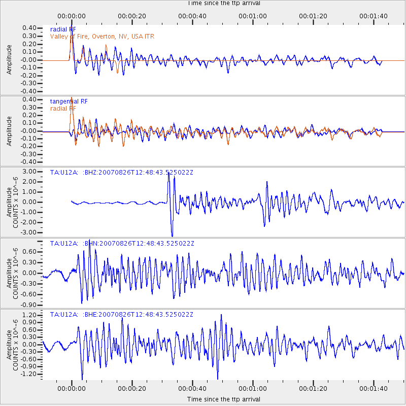
Signal To Noise
| Channel | StoN | STA | LTA |
| TA:U12A: :BHN:20070826T12:48:43.525022Z | 4.6700253 | 3.1409158E-7 | 6.7256934E-8 |
| TA:U12A: :BHE:20070826T12:48:43.525022Z | 4.469959 | 4.9390184E-7 | 1.104936E-7 |
| TA:U12A: :BHZ:20070826T12:48:43.525022Z | 20.812494 | 1.5062182E-6 | 7.237087E-8 |
| Arrivals |
| Ps | 4.1 SECOND |
| PpPs | 15 SECOND |
| PsPs/PpSs | 19 SECOND |


